38:
553:"}},"text\/plain":{"en":{"":"inception"}}},"{\"value\":{\"time\":\"+2011-05-01T00:00:00Z\",\"timezone\":0,\"before\":0,\"after\":0,\"precision\":11,\"calendarmodel\":\"http:\\\/\\\/www.wikidata.org\\\/entity\\\/Q1985727\"},\"type\":\"time\"}":{"text\/html":{"en":{"P571":"1 May 2011"}},"text\/plain":{"en":{"P571":"1 May 2011"}}}}": -->
261:
352:
267:
272:
94:
492:"}},"text\/plain":{"en":{"P275":"GNU Free Documentation License, version 1.2 or later"}}},"{\"value\":{\"entity-type\":\"item\",\"numeric-id\":14946043,\"id\":\"Q14946043\"},\"type\":\"wikibase-entityid\"}":{"text\/html":{"en":{"P275":"
488:"}},"text\/plain":{"en":{"":"copyright license"}}},"{\"value\":{\"entity-type\":\"item\",\"numeric-id\":50829104,\"id\":\"Q50829104\"},\"type\":\"wikibase-entityid\"}":{"text\/html":{"en":{"P275":"
444:"}},"text\/plain":{"en":{"":"copyright status"}}},"{\"value\":{\"entity-type\":\"item\",\"numeric-id\":50423863,\"id\":\"Q50423863\"},\"type\":\"wikibase-entityid\"}":{"text\/html":{"en":{"P6216":"
440:
959:
313:– You must give appropriate credit, provide a link to the license, and indicate if changes were made. You may do so in any reasonable manner, but not in any way that suggests the licensor endorses you or your use.
954:
493:
489:
445:
650:
region showing the administrative districts. Equirectangular map projection on WGS 84 datum, with N/S stretched 165% Geographic limits: *West: 3.3W *East: 1.1W *North:
441:
550:
485:
794:
226:
68:
64:
369:
60:
56:
52:
48:
42:
974:
924:
231:
105:
77:
969:
709:
699:
496:"}},"text\/plain":{"en":{"P275":"Creative Commons Attribution-ShareAlike 3.0 Unported"}}}}": -->
664:
367:; with no Invariant Sections, no Front-Cover Texts, and no Back-Cover Texts. A copy of the license is included in the section entitled
236:
536:
519:
471:
320:
714:
704:
694:
689:
684:
679:
674:
669:
455:
359:
560:
503:
430:
949:
809:
1012:
814:
734:
804:
282:
729:
364:
319:– If you remix, transform, or build upon the material, you must distribute your contributions under the
889:
628:
623:
37:
448:"}},"text\/plain":{"en":{"P6216":"copyrighted"}}}}": -->
190:
894:
879:
749:
113:
1027:
964:
919:
914:
864:
849:
799:
759:
859:
834:
357:
Permission is granted to copy, distribute and/or modify this document under the terms of the
1022:
944:
824:
279:
997:
8:
869:
754:
744:
899:
829:
789:
774:
960:
Knowledge:WikiProject
Navigation templates/Country subdivisions/United Kingdom/England
254:
I, the copyright holder of this work, hereby publish it under the following licenses:
100:
420:
904:
739:
187:
210:
955:
Knowledge:WikiProject
Countries/Templates/Navboxes/European country subdivisions
934:
884:
784:
639:
144:
929:
874:
779:
647:
909:
570:
530:
513:
465:
719:
150:
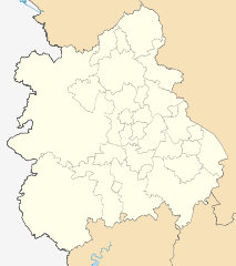
Equirectangular map projection on WGS 84 datum, with N/S stretched 165%
854:
724:
992:
346:
939:
844:
839:
819:
769:
596:
Click on a date/time to view the file as it appeared at that time.
1007:
82:(SVG file, nominally 1,161 × 1,306 pixels, file size: 1.33 MB)
764:
200:
Coastline data for Great
Britain (from Boundary-Line product)
176:
88:
1013:
Modèle:Géolocalisation/Midlands de l'Ouest (région)
414:
Add a one-line explanation of what this file represents
795:
List of boundary changes in the West
Midlands (region)
658:
983:
646:== Summary == {{Information |Description=Map of the
594:
537:
Creative
Commons Attribution-ShareAlike 3.0 Unported
520:
494:
Creative
Commons Attribution-ShareAlike 3.0 Unported
490:
363:, Version 1.2 or any later version published by the
112:
Commons is a freely licensed media file repository.
1028:
Module:Location map/data/West
Midlands (region)/doc
975:
Module:Location map/data/West
Midlands (region)/doc
925:
West Midlands Regional Women's Football League
227:NUTS 3 regions of the West Midlands 2010 map.svg
1023:Module:Location map/data/West Midlands (region)
970:Module:Location map/data/West Midlands (region)
330:https://creativecommons.org/licenses/by-sa/3.0
197:County boundaries (from Boundary-Line product)
93:
336:Creative Commons Attribution-Share Alike 3.0
260:
172:
147:region showing the administrative districts.
135:
998:Vorlage:Positionskarte England West Midlands
217:
206:
182:
14:
710:2023–24 North West Counties Football League
700:2022–23 North West Counties Football League
296:– to copy, distribute and transmit the work
232:NUTS 3 regions of the West Midlands map.svg
41:Size of this PNG preview of this SVG file:
395:You may select the license of your choice.
985:The following other wikis use this file:
665:2010–11 West Midlands (Regional) League
660:The following 63 pages use this file:
124:
375:http://www.gnu.org/copyleft/fdl.html
283:Attribution-Share Alike 3.0 Unported
213:, created using Ordnance Survey data
138:West Midlands districts 2011 map.svg
587:
271:
266:
237:West Midlands counties 2009 map.svg
13:
419:
413:
394:
257:
253:
125:
75:
1041:
950:User:Phildav76/Regional templates
418:
810:Metropolitan Borough of Solihull
404:
351:
350:
307:Under the following conditions:
278:This file is licensed under the
270:
265:
259:
92:
31:
21:
815:Metropolitan Borough of Walsall
735:Borough of Newcastle-under-Lyme
715:2024–25 Midland Football League
705:2023–24 Midland Football League
695:2022–23 Midland Football League
690:2021–22 Midland Football League
685:2020–21 Midland Football League
680:2019–20 Midland Football League
675:2018–19 Midland Football League
670:2014–15 Midland Football League
401:
222:Derivative works of this file:
980:
805:Metropolitan Borough of Dudley
591:
400:
381:GNU Free Documentation License
370:GNU Free Documentation License
360:GNU Free Documentation License
26:
1:
730:Birmingham Central Synagogue
655:
426:Items portrayed in this file
247:
7:
989:Usage on frr.wikipedia.org
10:
1046:
1019:Usage on si.wikipedia.org
1004:Usage on fr.wikipedia.org
890:Stratford-on-Avon District
321:same or compatible license
132:
127:
588:
16:
993:Waast Madlunen (Regiuun)
403:
365:Free Software Foundation
287:
99:This is a file from the
36:
895:Tamworth, Staffordshire
880:Staffordshire Moorlands
750:Broadwell, Warwickshire
645:
175:
103:. Information from its
965:Template:West Midlands
920:West Midlands (region)
915:West Midlands (county)
865:Singers Hill Synagogue
850:Shelton, Staffordshire
800:Malvern Hills District
760:Cannock Chase District
106:description page there
860:Shropshire (district)
835:Nuneaton and Bedworth
1008:Prison de Birmingham
945:Wyre Forest District
825:Newcastle-under-Lyme
69:1,161 × 1,306 pixels
65:1,821 × 2,048 pixels
870:South Staffordshire
755:Bromsgrove District
745:Borough of Stafford
302:– to adapt the work
153:Geographic limits:
47:Other resolutions:
900:Telford and Wrekin
830:North Warwickshire
790:Lichfield District
775:East Staffordshire
61:910 × 1,024 pixels
981:Global file usage
653:
624:19:06, 1 May 2011
504:copyright license
486:copyright license
412:
392:
391:
244:
243:
121:
120:
101:Wikimedia Commons
32:Global file usage
1037:
905:Warwick District
740:Borough of Rugby
636:
598:
456:copyright status
442:copyright status
410:
388:
385:
382:
379:
376:
354:
353:
347:
343:
340:
337:
334:
331:
323:as the original.
280:Creative Commons
274:
273:
269:
268:
263:
262:
178:
139:
133:
117:
96:
95:
89:
83:
72:
57:683 × 768 pixels
53:427 × 480 pixels
49:213 × 240 pixels
43:533 × 600 pixels
1045:
1044:
1040:
1039:
1038:
1036:
1035:
1034:
979:
654:
642:
634:
590:
589:
586:
585:
584:
583:
582:
581:
580:
579:
577:
567:
566:
565:
563:
548:
547:
546:
545:
544:
543:
542:
541:
539:
528:
527:
526:
525:
524:
522:
510:
509:
508:
506:
483:
482:
481:
480:
479:
478:
477:
476:
474:
462:
461:
460:
458:
439:
438:
437:
436:
435:
433:
417:
416:
415:
398:
397:
396:
386:
383:
380:
377:
374:
345:
344:
341:
338:
335:
332:
329:
328:
286:
275:
256:
255:
250:
245:
188:Ordnance Survey
137:
130:
123:
122:
111:
110:
109:is shown below.
85:
81:
74:
73:
46:
12:
11:
5:
1043:
1033:
1032:
1031:
1030:
1025:
1017:
1016:
1015:
1010:
1002:
1001:
1000:
995:
982:
978:
977:
972:
967:
962:
957:
952:
947:
942:
937:
935:Worcestershire
932:
927:
922:
917:
912:
907:
902:
897:
892:
887:
885:Stoke-on-Trent
882:
877:
872:
867:
862:
857:
852:
847:
842:
837:
832:
827:
822:
817:
812:
807:
802:
797:
792:
787:
785:Kites Hardwick
782:
777:
772:
767:
762:
757:
752:
747:
742:
737:
732:
727:
722:
717:
712:
707:
702:
697:
692:
687:
682:
677:
672:
667:
657:
652:
651:
644:
640:
637:
633:1,161 × 1,306
631:
626:
621:
617:
616:
613:
610:
607:
604:
601:
593:
578:
575:
573:
572:
571:
569:
568:
564:
559:
557:
556:
555:
554:
552:
540:
535:
533:
532:
531:
529:
523:
518:
516:
515:
514:
512:
511:
507:
502:
500:
499:
498:
497:
495:
491:
487:
475:
470:
468:
467:
466:
464:
463:
459:
454:
452:
451:
450:
449:
447:
443:
434:
429:
427:
424:
423:
422:
421:
409:
408:
405:
402:
393:
390:
389:
355:
327:
326:
325:
324:
314:
305:
304:
303:
297:
290:You are free:
277:
276:
258:
252:
251:
249:
246:
242:
241:
240:
239:
234:
229:
219:
218:Other versions
215:
214:
208:
204:
203:
202:
201:
198:
184:
180:
179:
174:
170:
169:
168:
167:
164:
161:
158:
140:
131:
129:
126:
119:
118:
97:
87:
86:
40:
35:
34:
29:
24:
19:
9:
6:
4:
3:
2:
1042:
1029:
1026:
1024:
1021:
1020:
1018:
1014:
1011:
1009:
1006:
1005:
1003:
999:
996:
994:
991:
990:
988:
987:
986:
976:
973:
971:
968:
966:
963:
961:
958:
956:
953:
951:
948:
946:
943:
941:
938:
936:
933:
931:
930:Wolverhampton
928:
926:
923:
921:
918:
916:
913:
911:
908:
906:
903:
901:
898:
896:
893:
891:
888:
886:
883:
881:
878:
876:
875:Staffordshire
873:
871:
868:
866:
863:
861:
858:
856:
853:
851:
848:
846:
843:
841:
838:
836:
833:
831:
828:
826:
823:
821:
818:
816:
813:
811:
808:
806:
803:
801:
798:
796:
793:
791:
788:
786:
783:
781:
780:Herefordshire
778:
776:
773:
771:
768:
766:
763:
761:
758:
756:
753:
751:
748:
746:
743:
741:
738:
736:
733:
731:
728:
726:
723:
721:
718:
716:
713:
711:
708:
706:
703:
701:
698:
696:
693:
691:
688:
686:
683:
681:
678:
676:
673:
671:
668:
666:
663:
662:
661:
649:
648:West Midlands
643:
638:
632:
630:
627:
625:
622:
619:
618:
614:
611:
608:
605:
602:
600:
599:
597:
574:
562:
558:
538:
534:
521:
517:
505:
501:
473:
469:
457:
453:
432:
428:
425:
406:
399:
372:
371:
366:
362:
361:
356:
349:
348:
333:CC BY-SA 3.0
322:
318:
315:
312:
309:
308:
306:
301:
298:
295:
292:
291:
289:
288:
284:
281:
264:
238:
235:
233:
230:
228:
225:
224:
223:
220:
216:
212:
209:
205:
199:
196:
195:
194:
192:
189:
185:
181:
171:
166:South: 51.75N
165:
163:North: 53.25N
162:
159:
156:
155:
154:
151:
148:
146:
145:West Midlands
141:
134:
115:
108:
107:
102:
98:
91:
90:
84:
79:
78:Original file
70:
66:
62:
58:
54:
50:
44:
39:
33:
30:
28:
25:
23:
20:
18:
15:
984:
910:Warwickshire
659:
595:
592:File history
368:
358:
316:
310:
299:
293:
221:
186:
152:
149:
142:
114:You can help
104:
76:
22:File history
720:Bignall End
472:copyrighted
446:copyrighted
317:share alike
311:attribution
143:Map of the
136:Description
855:Shropshire
725:Birmingham
656:File usage
609:Dimensions
576:1 May 2011
177:1 May 2011
160:East: 1.1W
157:West: 3.3W
27:File usage
641:Nilfanion
635:(1.33 MB)
606:Thumbnail
603:Date/Time
561:inception
551:inception
248:Licensing
211:Nilfanion
940:Wychavon
845:Sandwell
840:Redditch
820:Midlands
770:Coventry
407:Captions
300:to remix
294:to share
285:license.
191:OpenData
620:current
615:Comment
431:depicts
411:English
128:Summary
80:
207:Author
183:Source
765:Cound
612:User
387:true
384:true
378:GFDL
342:true
339:true
173:Date
17:File
193::
67:|
63:|
59:|
55:|
51:|
45:.
373:.
116:.
71:.
Text is available under the Creative Commons Attribution-ShareAlike License. Additional terms may apply.
