38:
553:"}},"text\/plain":{"en":{"":"inception"}}},"{\"value\":{\"time\":\"+2011-05-01T00:00:00Z\",\"timezone\":0,\"before\":0,\"after\":0,\"precision\":11,\"calendarmodel\":\"http:\\\/\\\/www.wikidata.org\\\/entity\\\/Q1985727\"},\"type\":\"time\"}":{"text\/html":{"en":{"P571":"1 May 2011"}},"text\/plain":{"en":{"P571":"1 May 2011"}}}}": -->
1182:
261:
1177:
352:
267:
272:
94:
492:"}},"text\/plain":{"en":{"P275":"GNU Free Documentation License, version 1.2 or later"}}},"{\"value\":{\"entity-type\":\"item\",\"numeric-id\":14946043,\"id\":\"Q14946043\"},\"type\":\"wikibase-entityid\"}":{"text\/html":{"en":{"P275":"
488:"}},"text\/plain":{"en":{"":"copyright license"}}},"{\"value\":{\"entity-type\":\"item\",\"numeric-id\":50829104,\"id\":\"Q50829104\"},\"type\":\"wikibase-entityid\"}":{"text\/html":{"en":{"P275":"
444:"}},"text\/plain":{"en":{"":"copyright status"}}},"{\"value\":{\"entity-type\":\"item\",\"numeric-id\":50423863,\"id\":\"Q50423863\"},\"type\":\"wikibase-entityid\"}":{"text\/html":{"en":{"P6216":"
440:
549:
313:– You must give appropriate credit, provide a link to the license, and indicate if changes were made. You may do so in any reasonable manner, but not in any way that suggests the licensor endorses you or your use.
68:
64:
60:
56:
52:
48:
42:
493:
489:
445:
226:
105:
77:
441:
550:
485:
231:
1139:
1009:
1004:
369:
236:
914:
909:
904:
894:
889:
884:
879:
874:
869:
864:
859:
854:
849:
844:
839:
834:
829:
824:
819:
814:
809:
804:
799:
794:
789:
1134:
650:
region showing the administrative districts. Equirectangular map projection on WGS 84 datum, with N/S stretched 170% Geographic limits: *West: 2.
1034:
496:"}},"text\/plain":{"en":{"P275":"Creative Commons Attribution-ShareAlike 3.0 Unported"}}}}": -->
1312:
367:; with no Invariant Sections, no Front-Cover Texts, and no Back-Cover Texts. A copy of the license is included in the section entitled
1162:
536:
519:
471:
784:
779:
774:
769:
764:
759:
754:
749:
744:
739:
734:
729:
724:
719:
714:
709:
704:
699:
694:
689:
684:
679:
674:
669:
664:
320:
455:
359:
560:
503:
430:
1129:
1114:
1019:
1119:
1014:
899:
628:
623:
37:
1157:
282:
364:
319:– If you remix, transform, or build upon the material, you must distribute your contributions under the
1049:
1207:
448:"}},"text\/plain":{"en":{"P6216":"copyrighted"}}}}": -->
144:
1237:
1124:
1109:
1084:
1054:
979:
647:
1302:
1287:
190:
1227:
1089:
1029:
113:
1297:
1282:
1064:
984:
954:
357:
Permission is granted to copy, distribute and/or modify this document under the terms of the
974:
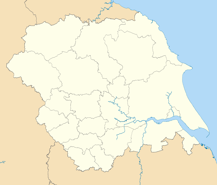
969:
964:
959:
279:
8:
1104:
1039:
994:
944:
939:
929:
254:
I, the copyright holder of this work, hereby publish it under the following licenses:
100:
420:
1079:
924:
187:
1172:
1094:
1044:
210:
1099:
639:
1272:
1242:
1059:
934:
1024:
989:
949:
570:
530:
513:
465:
150:
Equirectangular map projection on WGS 84 datum, with N/S stretched 170%
1074:
1069:
919:
1267:
346:
1222:
1202:
999:
596:
Click on a date/time to view the file as it appeared at that time.
1217:
1183:মডিউল:অবস্থান মানচিত্র/উপাত্ত/ইয়র্কশায়ার এবং দ্য হাম্বার/নথি
82:(SVG file, nominally 1,425 × 1,212 pixels, file size: 1.22 MB)
1257:
1252:
200:
Coastline data for Great
Britain (from Boundary-Line product)
1178:মডিউল:অবস্থান মানচিত্র/উপাত্ত/ইয়র্কশায়ার এবং দ্য হাম্বার
176:
88:
1238:
Template:Mappa di localizzazione/GBR Yorkshire e Humber
1208:
Vorlage:Positionskarte
England Yorkshire and the Humber
414:
Add a one-line explanation of what this file represents
227:
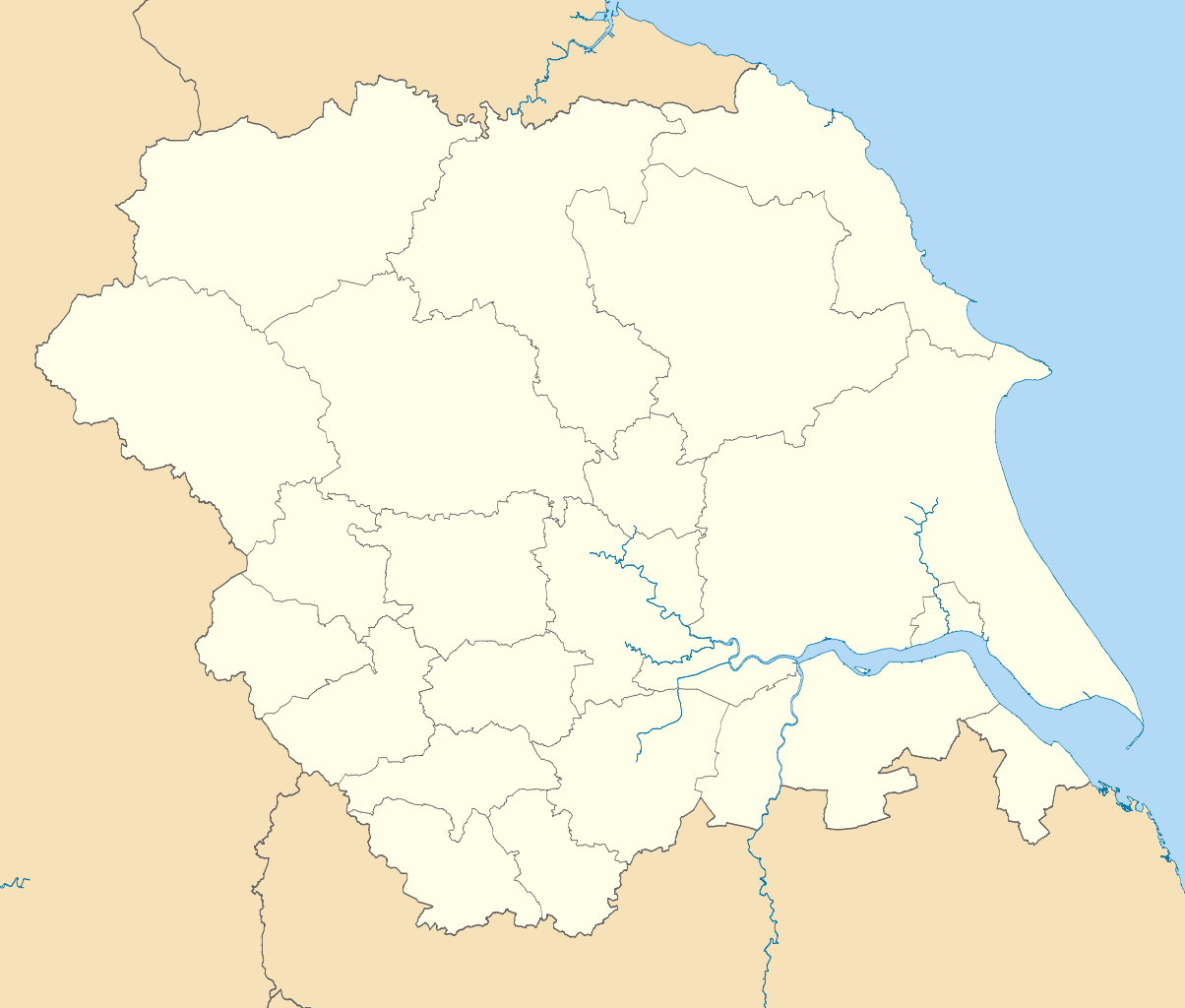
NUTS 3 regions of
Yorkshire and the Humber 2010 map.svg
1303:
Module:Location map/data/Yorkshire and the Humber/doc
1288:
Module:Location map/data/Yorkshire and the Humber/doc
1140:
Module:Location map/data/Yorkshire and the Humber/doc
658:
1148:
1010:
List of settlements in North
Yorkshire by population
1005:
List of boundary changes in
Yorkshire and the Humber
646:== Summary == {{Information |Description=Map of the
594:
537:
Creative
Commons Attribution-ShareAlike 3.0 Unported
520:
494:
Creative
Commons Attribution-ShareAlike 3.0 Unported
490:
363:, Version 1.2 or any later version published by the
112:
Commons is a freely licensed media file repository.
1163:وحدة:Location map/data/Yorkshire and the Humber/شرح
1262:
232:NUTS 3 regions of Yorkshire and the Humber map.svg
1298:Module:Location map/data/Yorkshire and the Humber
1283:Module:Location map/data/Yorkshire and the Humber
1135:Module:Location map/data/Yorkshire and the Humber
1035:North East Regional Women's Football League
1158:وحدة:Location map/data/Yorkshire and the Humber
138:Yorkshire and the Humber districts 2011 map.svg
915:2024–25 Northern Counties East Football League
910:2023–24 Northern Counties East Football League
905:2022–23 Northern Counties East Football League
895:2021–22 Northern Counties East Football League
890:2020–21 Northern Counties East Football League
885:2019–20 Northern Counties East Football League
880:2018–19 Northern Counties East Football League
875:2017–18 Northern Counties East Football League
870:2016–17 Northern Counties East Football League
865:2015–16 Northern Counties East Football League
860:2014–15 Northern Counties East Football League
855:2013–14 Northern Counties East Football League
850:2012–13 Northern Counties East Football League
845:1993–94 Northern Counties East Football League
840:1992–93 Northern Counties East Football League
835:1991–92 Northern Counties East Football League
830:1990–91 Northern Counties East Football League
825:1989–90 Northern Counties East Football League
820:1988–89 Northern Counties East Football League
815:1987–88 Northern Counties East Football League
810:1986–87 Northern Counties East Football League
805:1985–86 Northern Counties East Football League
800:1984–85 Northern Counties East Football League
795:1983–84 Northern Counties East Football League
790:1982–83 Northern Counties East Football League
330:https://creativecommons.org/licenses/by-sa/3.0
237:Yorkshire and the Humber counties 2009 map.svg
197:County boundaries (from Boundary-Line product)
93:
336:Creative Commons Attribution-Share Alike 3.0
260:
172:
147:region showing the administrative districts.
135:
217:
206:
182:
14:
1193:مسابقات قهرمانی دوچرخهسواری جاده جهان ۲۰۱۹
296:– to copy, distribute and transmit the work
41:Size of this PNG preview of this SVG file:
1228:Modèle:Géolocalisation/Yorkshire-et-Humber
395:You may select the license of your choice.
1150:The following other wikis use this file:
660:The following 96 pages use this file:
124:
375:http://www.gnu.org/copyleft/fdl.html
283:Attribution-Share Alike 3.0 Unported
213:, created using Ordnance Survey data
587:
271:
266:
13:
419:
413:
394:
257:
253:
125:
75:
1326:
1243:Yorkshire Rose Winter League 1993
1130:Template:Yorkshire and the Humber
1115:User:Phildav76/Regional templates
1020:Metropolitan Borough of Rotherham
785:1981–82 Yorkshire Football League
780:1980–81 Yorkshire Football League
775:1979–80 Yorkshire Football League
770:1978–79 Yorkshire Football League
765:1977–78 Yorkshire Football League
760:1976–77 Yorkshire Football League
755:1975–76 Yorkshire Football League
750:1974–75 Yorkshire Football League
745:1973–74 Yorkshire Football League
740:1972–73 Yorkshire Football League
735:1971–72 Yorkshire Football League
730:1970–71 Yorkshire Football League
725:1969–70 Yorkshire Football League
720:1968–69 Yorkshire Football League
715:1967–68 Yorkshire Football League
710:1966–67 Yorkshire Football League
705:1965–66 Yorkshire Football League
700:1964–65 Yorkshire Football League
695:1963–64 Yorkshire Football League
690:1962–63 Yorkshire Football League
685:1961–62 Yorkshire Football League
680:1950–51 Yorkshire Football League
675:1949–50 Yorkshire Football League
670:1921–22 Yorkshire Football League
665:1920–21 Yorkshire Football League
418:
1273:Template:Yorkshire an the Humber
1120:User:Skinsmoke/Sandbox/Sheffield
1015:Metropolitan Borough of Barnsley
900:2022 Sheffield gas supply outage
404:
351:
350:
307:Under the following conditions:
278:This file is licensed under the
270:
265:
259:
92:
31:
21:
401:
222:Derivative works of this file:
1145:
591:
400:
381:GNU Free Documentation License
370:GNU Free Documentation License
360:GNU Free Documentation License
26:
1:
655:
426:Items portrayed in this file
247:
7:
1249:Usage on sco.wikipedia.org
1199:Usage on frr.wikipedia.org
10:
1331:
1309:Usage on zh.wikipedia.org
1294:Usage on uz.wikipedia.org
1279:Usage on si.wikipedia.org
1234:Usage on it.wikipedia.org
1214:Usage on fr.wikipedia.org
1189:Usage on fa.wikipedia.org
1169:Usage on bn.wikipedia.org
1154:Usage on ar.wikipedia.org
1050:North Yorkshire (district)
321:same or compatible license
132:
127:
588:
16:
1268:East Riding of Yorkshire
1125:User talk:Huon/Archive20
1110:Yorkshire and the Humber
1085:Shiregreen child murders
1055:Northern Football League
980:East Riding of Yorkshire
648:Yorkshire and the Humber
403:
365:Free Software Foundation
287:
145:Yorkshire and the Humber
99:This is a file from the
36:
1090:Sinai Synagogue (Leeds)
1030:North East Lincolnshire
645:
175:
103:. Information from its
106:description page there
1203:Yorkshire an a Humber
1065:Regional 2 North East
985:Hull Reform Synagogue
955:Cliffe, Richmondshire
975:Counties 4 Yorkshire
970:Counties 3 Yorkshire
965:Counties 2 Yorkshire
960:Counties 1 Yorkshire
69:1,425 × 1,212 pixels
65:2,408 × 2,048 pixels
61:1,204 × 1,024 pixels
1218:Prison de Wakefield
1105:Yorkshire Wolds Way
302:– to adapt the work
153:Geographic limits:
47:Other resolutions:
1040:North Lincolnshire
995:Kingston upon Hull
1223:Château de Bolton
1146:Global file usage
945:City of Wakefield
940:City of Sheffield
930:City of Doncaster
653:
624:19:07, 1 May 2011
504:copyright license
486:copyright license
412:
392:
391:
244:
243:
121:
120:
101:Wikimedia Commons
32:Global file usage
1322:
1080:Seven Hills Shul
925:City of Bradford
636:
598:
456:copyright status
442:copyright status
410:
388:
385:
382:
379:
376:
354:
353:
347:
343:
340:
337:
334:
331:
323:as the original.
280:Creative Commons
274:
273:
269:
268:
263:
262:
178:
139:
133:
117:
96:
95:
89:
83:
72:
57:903 × 768 pixels
53:564 × 480 pixels
49:282 × 240 pixels
43:705 × 600 pixels
1330:
1329:
1325:
1324:
1323:
1321:
1320:
1319:
1258:North Yorkshire
1253:Sooth Yorkshire
1144:
1095:South Yorkshire
1045:North Yorkshire
654:
642:
634:
590:
589:
586:
585:
584:
583:
582:
581:
580:
579:
577:
567:
566:
565:
563:
548:
547:
546:
545:
544:
543:
542:
541:
539:
528:
527:
526:
525:
524:
522:
510:
509:
508:
506:
483:
482:
481:
480:
479:
478:
477:
476:
474:
462:
461:
460:
458:
439:
438:
437:
436:
435:
433:
417:
416:
415:
398:
397:
396:
386:
383:
380:
377:
374:
345:
344:
341:
338:
335:
332:
329:
328:
286:
275:
256:
255:
250:
245:
188:Ordnance Survey
137:
130:
123:
122:
111:
110:
109:is shown below.
85:
81:
74:
73:
46:
12:
11:
5:
1328:
1318:
1317:
1316:
1315:
1307:
1306:
1305:
1300:
1292:
1291:
1290:
1285:
1277:
1276:
1275:
1270:
1265:
1260:
1255:
1247:
1246:
1245:
1240:
1232:
1231:
1230:
1225:
1220:
1212:
1211:
1210:
1205:
1197:
1196:
1195:
1187:
1186:
1185:
1180:
1175:
1167:
1166:
1165:
1160:
1147:
1143:
1142:
1137:
1132:
1127:
1122:
1117:
1112:
1107:
1102:
1100:West Yorkshire
1097:
1092:
1087:
1082:
1077:
1072:
1067:
1062:
1057:
1052:
1047:
1042:
1037:
1032:
1027:
1022:
1017:
1012:
1007:
1002:
997:
992:
987:
982:
977:
972:
967:
962:
957:
952:
947:
942:
937:
932:
927:
922:
917:
912:
907:
902:
897:
892:
887:
882:
877:
872:
867:
862:
857:
852:
847:
842:
837:
832:
827:
822:
817:
812:
807:
802:
797:
792:
787:
782:
777:
772:
767:
762:
757:
752:
747:
742:
737:
732:
727:
722:
717:
712:
707:
702:
697:
692:
687:
682:
677:
672:
667:
657:
652:
651:
644:
640:
637:
633:1,425 × 1,212
631:
626:
621:
617:
616:
613:
610:
607:
604:
601:
593:
578:
575:
573:
572:
571:
569:
568:
564:
559:
557:
556:
555:
554:
552:
540:
535:
533:
532:
531:
529:
523:
518:
516:
515:
514:
512:
511:
507:
502:
500:
499:
498:
497:
495:
491:
487:
475:
470:
468:
467:
466:
464:
463:
459:
454:
452:
451:
450:
449:
447:
443:
434:
429:
427:
424:
423:
422:
421:
409:
408:
405:
402:
393:
390:
389:
355:
327:
326:
325:
324:
314:
305:
304:
303:
297:
290:You are free:
277:
276:
258:
252:
251:
249:
246:
242:
241:
240:
239:
234:
229:
219:
218:Other versions
215:
214:
208:
204:
203:
202:
201:
198:
184:
180:
179:
174:
170:
169:
168:
167:
164:
161:
158:
140:
131:
129:
126:
119:
118:
97:
87:
86:
40:
35:
34:
29:
24:
19:
9:
6:
4:
3:
2:
1327:
1314:
1311:
1310:
1308:
1304:
1301:
1299:
1296:
1295:
1293:
1289:
1286:
1284:
1281:
1280:
1278:
1274:
1271:
1269:
1266:
1264:
1261:
1259:
1256:
1254:
1251:
1250:
1248:
1244:
1241:
1239:
1236:
1235:
1233:
1229:
1226:
1224:
1221:
1219:
1216:
1215:
1213:
1209:
1206:
1204:
1201:
1200:
1198:
1194:
1191:
1190:
1188:
1184:
1181:
1179:
1176:
1174:
1171:
1170:
1168:
1164:
1161:
1159:
1156:
1155:
1153:
1152:
1151:
1141:
1138:
1136:
1133:
1131:
1128:
1126:
1123:
1121:
1118:
1116:
1113:
1111:
1108:
1106:
1103:
1101:
1098:
1096:
1093:
1091:
1088:
1086:
1083:
1081:
1078:
1076:
1073:
1071:
1068:
1066:
1063:
1061:
1060:Potteric Carr
1058:
1056:
1053:
1051:
1048:
1046:
1043:
1041:
1038:
1036:
1033:
1031:
1028:
1026:
1023:
1021:
1018:
1016:
1013:
1011:
1008:
1006:
1003:
1001:
998:
996:
993:
991:
988:
986:
983:
981:
978:
976:
973:
971:
968:
966:
963:
961:
958:
956:
953:
951:
948:
946:
943:
941:
938:
936:
935:City of Leeds
933:
931:
928:
926:
923:
921:
918:
916:
913:
911:
908:
906:
903:
901:
898:
896:
893:
891:
888:
886:
883:
881:
878:
876:
873:
871:
868:
866:
863:
861:
858:
856:
853:
851:
848:
846:
843:
841:
838:
836:
833:
831:
828:
826:
823:
821:
818:
816:
813:
811:
808:
806:
803:
801:
798:
796:
793:
791:
788:
786:
783:
781:
778:
776:
773:
771:
768:
766:
763:
761:
758:
756:
753:
751:
748:
746:
743:
741:
738:
736:
733:
731:
728:
726:
723:
721:
718:
716:
713:
711:
708:
706:
703:
701:
698:
696:
693:
691:
688:
686:
683:
681:
678:
676:
673:
671:
668:
666:
663:
662:
661:
649:
643:
638:
632:
630:
627:
625:
622:
619:
618:
614:
611:
608:
605:
602:
600:
599:
597:
574:
562:
558:
538:
534:
521:
517:
505:
501:
473:
469:
457:
453:
432:
428:
425:
406:
399:
372:
371:
366:
362:
361:
356:
349:
348:
333:CC BY-SA 3.0
322:
318:
315:
312:
309:
308:
306:
301:
298:
295:
292:
291:
289:
288:
284:
281:
264:
238:
235:
233:
230:
228:
225:
224:
223:
220:
216:
212:
209:
205:
199:
196:
195:
194:
192:
189:
185:
181:
171:
165:
163:North: 54.65N
162:
159:
156:
155:
154:
151:
148:
146:
141:
134:
115:
108:
107:
102:
98:
91:
90:
84:
79:
78:Original file
70:
66:
62:
58:
54:
50:
44:
39:
33:
30:
28:
25:
23:
20:
18:
15:
1149:
1025:North 1 East
990:Humber derby
950:City of York
659:
595:
592:File history
368:
358:
316:
310:
299:
293:
221:
186:
166:South: 53.2N
152:
149:
142:
114:You can help
104:
76:
22:File history
472:copyrighted
446:copyrighted
317:share alike
311:attribution
160:East: 0.25E
157:West: 2.65W
143:Map of the
136:Description
1313:英格蘭足球俱樂部列表
1075:Saltmarshe
1070:River Nidd
920:Calderdale
656:File usage
609:Dimensions
576:1 May 2011
177:1 May 2011
27:File usage
641:Nilfanion
635:(1.22 MB)
606:Thumbnail
603:Date/Time
561:inception
551:inception
248:Licensing
211:Nilfanion
1000:Kirklees
407:Captions
300:to remix
294:to share
285:license.
191:OpenData
620:current
615:Comment
431:depicts
411:English
128:Summary
80:
207:Author
183:Source
1263:York
1173:লিডস
612:User
387:true
384:true
378:GFDL
342:true
339:true
173:Date
17:File
193::
67:|
63:|
59:|
55:|
51:|
45:.
373:.
116:.
71:.
Text is available under the Creative Commons Attribution-ShareAlike License. Additional terms may apply.
