38:
45:
250:, Governor of Kirundo, praised the achievements of Inades-Formation Burundi in creating buffer zones for the Nagitamo, Mwungere and Gacamirinda lakes. The protective belt includes trees, anti-erosion ditches with fixation grasses above them, and a canal separating the buffer zone from private properties. Fish production and water quality has improved in the protected lakes as a result.
191:, created in 2006, which in theory conserves more than 30,000 hectares (74,000 acres) of lakes and wetlands with the goal of integrated community management, agricultural production, and lake conservation. The lake is part of the Northern Protected Waterway, a 162.42 square kilometres (62.71 sq mi) complex of 8 permanent freshwater lakes including lakes
235:, which has greatly decreased production and reduced fish stocks, as well as crowded out native vegetation. Burundi has taken little effort to remove the invasive species.
242:
area. Lake
Mwungere is considered an Integral Zone under this plan, which includes lakes Gacamirina and Nagitamo, and marshlands in the secondary valleys of the
247:
345:
188:
84:
246:. Human influence should be excluded from the zone by a 50 metres (160 ft) belt to protect the natural species. In November 2021
448:
453:
394:
Towards ownership of the achievements of the TAPSA project by the local administration of
Bugabira and Ntega communes
123:
238:
The Kagera
Aquatic Zone's Management Plan aims to improve management of the lakes, marshlands and vegetation in the
37:
176:
427:
359:
410:
USAID/Burundi
Foreign Assistance Act Sections 118/119 Tropical Forests and Biodiversity Analysis
171:
in
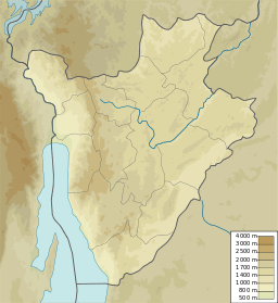
Kirundo Province near the villages of Mariza and Mugina. It is connected by wetlands to the
8:
208:
168:
152:
66:
243:
232:
216:
204:
172:
408:
336:
442:
375:
239:
212:
200:
138:
125:
99:
86:
392:
228:
196:
361:
Kagera TAMP - Bugesera aquatic landscapes endowed with a management plan
220:
192:
313:
274:
338:
Burundi
Environmental Threats and Opportunities Assessment (ETOA)
224:
156:
70:
291:
289:
231:
species. They have been the site of largescale invasions of
286:
264:
262:
391:
319:
259:
335:
280:
219:
and
Mwungere as well as marshes, that form part of the
301:
346:United States Agency for International Development
440:
77:
374:
407:
295:
426:
364:, Kirundo province, Burundi: FAO, 8 July 2011
268:
189:Lacs du Nord Aquatic Landscape Protected Area
397:, Inades-Formation Burundi, 29 November 2021
358:
307:
376:"Lac Mwungere, Kirundo Province, Burundi"
441:
223:. These lakes are dominated by small
44:
13:
14:
465:
43:
36:
428:"Way: Lac Mwungere (299661662)"
182:
179:is Aw: Tropical savanna, wet.
1:
253:
177:Köppen climate classification
320:Towards ownership ... Inades
7:
281:BurundiEnvironmentalThreats
162:
10:
470:
449:Protected areas of Burundi
328:
454:Lakes of Kirundo Province
76:
62:
31:
26:
21:
187:Lake Mwungere is in the
167:Lake Mwungere is in the
348:(USAID), September 2010
139:2.57861°S 29.94667°E
100:2.57861°S 29.94667°E
151:) is a lake in the
135: /
96: /
296:USAID/Burundi 2022
248:Albert Hatungimana
144:-2.57861; 29.94667
105:-2.57861; 29.94667
269:Way: Lac Mwungere
115:
114:
461:
434:
423:
422:
421:
415:
404:
403:
402:
388:
387:
386:
371:
370:
369:
355:
354:
353:
343:
323:
317:
311:
305:
299:
293:
284:
278:
272:
266:
169:Commune of Ntega
153:Kirundo Province
150:
149:
147:
146:
145:
140:
136:
133:
132:
131:
128:
111:
110:
108:
107:
106:
101:
97:
94:
93:
92:
89:
79:
67:Kirundo Province
47:
46:
40:
19:
18:
469:
468:
464:
463:
462:
460:
459:
458:
439:
438:
437:
419:
417:
413:
400:
398:
384:
382:
367:
365:
351:
349:
341:
331:
326:
318:
314:
308:Kagera TAMP FAO
306:
302:
294:
287:
279:
275:
267:
260:
256:
185:
165:
143:
141:
137:
134:
129:
126:
124:
122:
121:
104:
102:
98:
95:
90:
87:
85:
83:
82:
58:
57:
56:
55:
54:
53:
52:
48:
17:
16:Lake in Burundi
12:
11:
5:
467:
457:
456:
451:
436:
435:
424:
405:
389:
372:
356:
332:
330:
327:
325:
324:
312:
300:
285:
273:
257:
255:
252:
244:Akanyaru River
233:water hyacinth
184:
181:
173:Akanyaru River
164:
161:
113:
112:
80:
74:
73:
64:
60:
59:
50:
49:
42:
41:
35:
34:
33:
32:
29:
28:
24:
23:
15:
9:
6:
4:
3:
2:
466:
455:
452:
450:
447:
446:
444:
433:
432:OpenStreetMap
429:
425:
412:
411:
406:
396:
395:
390:
381:
377:
373:
363:
362:
357:
347:
340:
339:
334:
333:
321:
316:
309:
304:
298:, p. 17.
297:
292:
290:
282:
277:
270:
265:
263:
258:
251:
249:
245:
241:
240:Murehe Forest
236:
234:
230:
226:
222:
218:
214:
210:
206:
202:
198:
194:
190:
180:
178:
174:
170:
160:
158:
154:
148:
119:
118:Lake Mwungere
109:
81:
75:
72:
68:
65:
61:
51:Lake Mwungere
39:
30:
25:
22:Lake Mwungere
20:
431:
418:, retrieved
409:
399:, retrieved
393:
383:, retrieved
379:
366:, retrieved
360:
350:, retrieved
337:
315:
303:
276:
237:
186:
183:Conservation
166:
117:
116:
27:Lac Mwungere
416:, June 2022
229:Oreochromis
209:Gacamirindi
142: /
103: /
78:Coordinates
443:Categories
420:2024-06-09
401:2024-06-09
385:2024-06-09
368:2024-06-09
352:2024-06-09
254:References
221:Nile Basin
130:29°56′48″E
91:29°56′48″E
217:Narungazi
205:Kanzigiri
127:2°34′43″S
88:2°34′43″S
213:Nagitamo
201:Rwihinda
163:Location
63:Location
329:Sources
225:Tilapia
157:Burundi
71:Burundi
380:Mindat
197:Cohoha
175:. The
414:(PDF)
342:(PDF)
193:Rweru
227:and
155:of
69:of
445::
430:,
378:,
344:,
288:^
261:^
215:,
211:,
207:,
203:,
199:,
195:,
159:.
322:.
310:.
283:.
271:.
120:(
Text is available under the Creative Commons Attribution-ShareAlike License. Additional terms may apply.
