48:
299:
75:
308:
290:
566:
252:, who explored the West Coast region in the 1860s. The lake is bounded on its eastern side by the main fault scarp of the Alpine Fault, and is believed to be very recent in geological age. Lake Poerua sits on the Australia-Pacific plate boundary, with granite rock from the Australian plate to the west and metasedimentary rocks from the Pacific plate to the east.
68:
537:
255:
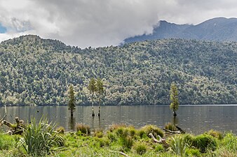
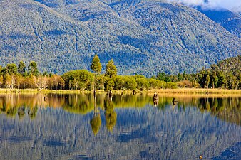
The lake is popular with trout fishermen and is easily accessible from the adjacent road. The lake has submerged or partly submerged tree stumps and large granite boulders at or below the waterline that can present a hazard for boating.
419:
530:
408:
280:
A wetland on the shores of the north end of Lake Poerua has been identified in a schedule of
Significant Wetlands of the West Coast Region, published by Westland Regional Council.
448:
508:
478:
1124:
361:"Late Holocene landscape change history related to the Alpine Fault determined from drowned forests in Lake Poerua, Westland, New Zealand"
337:
47:
114:
955:
1155:
604:
1104:
264:
1129:
965:
1040:
444:
233:, to the north of the lake. The area around Lake Poerua is sparsely populated. A number of small
814:
899:
834:
570:
238:
153:
67:
864:
839:
597:
1025:
849:
242:
904:
268:
1035:
854:
789:
737:
329:
577:
1119:
1030:
500:
470:
218:
96:
1150:
945:
732:
692:
590:
1092:
1066:
1005:
995:
990:
985:
980:
763:
742:
623:
146:
970:
940:
844:
768:
697:
8:
869:
702:
666:
656:
879:
975:
722:
1076:
960:
784:
661:
382:
204:
37:
950:
914:
824:
390:
372:
249:
1109:
1010:
909:
819:
277:
The lake and surrounding area has been a popular place for visitors and picnics.
1098:
1020:
1015:
377:
360:
230:
160:
1144:
1114:
1071:
1045:
1000:
924:
919:
889:
613:
582:
386:
129:
116:
358:
1050:
829:
809:
226:
222:
100:
394:
298:
248:
The first description of the lake by
Europeans comes from the journeys of
874:
859:
884:
712:
260:
147:
758:
651:
642:
627:
671:
409:"Accident Report - fatality - unnamed Canadian canoe - 23 May 2008"
359:
R. M. Langridge; R. Basili; L. Basher; A. P. Wells (26 June 2012).
727:
707:
307:
289:
271:
717:
687:
565:
234:
229:. It is located between the Alexander Range and the slopes of
578:
Kingfisher Fly
Fishing - Lake Poerua, West Coast, New Zealand
214:
259:The lake is just to the north of the settlement of
501:"Combined schools picnic - the beauties of Poerua"
1142:
107:
52:Willow and kahikatea reflections at Lake Poerua
612:
598:
1125:West Coast Historical and Mechanical Society
29:
605:
591:
956:Blackball Museum of Working Class History
376:
365:Natural Hazards and Earth System Sciences
274:run along the eastern shore of the lake.
334:www.fly-fishing-guides-new-zealand.co.nz
1143:
531:"Regional Plans - Land and Water Plan"
330:"Lake Poerua - West Coast New Zealand"
586:
543:from the original on 23 February 2022
425:from the original on 16 February 2022
340:from the original on 26 January 2022
74:
13:
225:roughly 13 km southeast from
14:
1167:
559:
511:from the original on 15 July 2022
481:from the original on 15 July 2022
471:"Poerua - an ideal picnic resort"
451:from the original on 15 July 2022
263:, and Lake Brunner Road (linking
564:
306:
297:
288:
73:
66:
46:
1130:West Coast Rugby Football Union
245:, which leads to Lake Brunner.
1156:Lakes of the West Coast Region
523:
493:
463:
437:
401:
352:
322:
1:
536:. Westland Regional Council.
315:
241:flows from the lake into the
237:flow into the lake, and the
7:
10:
1172:
934:Facilities and attractions
850:Greenstone River / Hokonui
378:10.5194/NHESS-12-2051-2012
178:212.7 hectares (526 acres)
1085:
1059:
933:
802:
777:
751:
680:
641:
634:
621:
190:
182:
174:
170:
159:
145:
106:
92:
61:
57:
45:
28:
23:
1105:John Paul II High School
1041:Stillwater–Ngākawau Line
1036:Shantytown Heritage Park
519:– via Papers Past.
489:– via Papers Past.
221:region of New Zealand's
194:125 metres (410 ft)
1120:Tai Poutini Polytechnic
855:Grey River / Māwheranui
284:Lake Poerua impressions
265:State Highways 7 and 73
186:6.9 metres (23 ft)
946:Bell Hill mill tramway
505:Greymouth Evening Star
475:Greymouth Evening Star
208:
30:
1093:Greymouth High School
1006:Pike29 Memorial Track
996:Paparoa National Park
991:Omoto locomotive dump
986:Left Bank Art Gallery
981:Kotuku Model Bungalow
573:at Wikimedia Commons
445:"NZ Topo maps online"
1031:Runanga Miners' Hall
971:History House Museum
941:Arnold Power Station
845:Eastern Hohonu River
507:. 12 February 1912.
416:Maritime New Zealand
870:Little Hohonu River
803:Geographic features
477:. 17 January 1912.
126: /
16:Lake in New Zealand
976:John Sturgeon Park
130:42.700°S 171.500°E
1138:
1137:
966:Hannah's Building
961:Greymouth Airport
798:
797:
662:Greymouth Central
569:Media related to
198:
197:
191:Surface elevation
1163:
1077:Regional Council
1067:District Council
951:Blackball Branch
915:Upper Grey River
880:Ōrangipuku River
639:
638:
635:Populated places
607:
600:
593:
584:
583:
568:
553:
552:
550:
548:
542:
535:
527:
521:
520:
518:
516:
497:
491:
490:
488:
486:
467:
461:
460:
458:
456:
441:
435:
434:
432:
430:
424:
413:
405:
399:
398:
380:
371:(6): 2051–2064.
356:
350:
349:
347:
345:
326:
310:
301:
292:
250:Julius von Haast
149:
148:Primary outflows
141:
140:
138:
137:
136:
135:-42.700; 171.500
131:
127:
124:
123:
122:
119:
109:
77:
76:
70:
50:
41:
33:
21:
20:
1171:
1170:
1166:
1165:
1164:
1162:
1161:
1160:
1141:
1140:
1139:
1134:
1110:Pike River Coal
1081:
1055:
1011:Pike River Mine
929:
910:Taramakau River
820:Barrytown Flats
815:Alexander River
794:
773:
747:
676:
630:
617:
611:
562:
557:
556:
546:
544:
540:
533:
529:
528:
524:
514:
512:
499:
498:
494:
484:
482:
469:
468:
464:
454:
452:
443:
442:
438:
428:
426:
422:
411:
407:
406:
402:
357:
353:
343:
341:
328:
327:
323:
318:
311:
302:
293:
217:located in the
213:) is a shallow
163: countries
134:
132:
128:
125:
120:
117:
115:
113:
112:
88:
87:
86:
85:
84:
83:
82:
78:
53:
35:
17:
12:
11:
5:
1169:
1159:
1158:
1153:
1136:
1135:
1133:
1132:
1127:
1122:
1117:
1112:
1107:
1102:
1099:Greymouth Star
1095:
1089:
1087:
1083:
1082:
1080:
1079:
1074:
1069:
1063:
1061:
1057:
1056:
1054:
1053:
1048:
1043:
1038:
1033:
1028:
1023:
1021:Rewanui Branch
1018:
1016:Rapahoe Branch
1013:
1008:
1003:
998:
993:
988:
983:
978:
973:
968:
963:
958:
953:
948:
943:
937:
935:
931:
930:
928:
927:
922:
917:
912:
907:
902:
897:
892:
887:
882:
877:
872:
867:
862:
857:
852:
847:
842:
837:
832:
827:
822:
817:
812:
806:
804:
800:
799:
796:
795:
793:
792:
787:
781:
779:
775:
774:
772:
771:
766:
761:
755:
753:
749:
748:
746:
745:
740:
735:
730:
725:
720:
715:
710:
705:
700:
695:
690:
684:
682:
678:
677:
675:
674:
669:
664:
659:
654:
648:
646:
636:
632:
631:
622:
619:
618:
610:
609:
602:
595:
587:
581:
580:
561:
560:External links
558:
555:
554:
522:
492:
462:
436:
400:
351:
320:
319:
317:
314:
313:
312:
305:
303:
296:
294:
287:
285:
231:Mount Te Kinga
196:
195:
192:
188:
187:
184:
180:
179:
176:
172:
171:
168:
167:
164:
157:
156:
151:
143:
142:
110:
104:
103:
94:
90:
89:
80:
79:
72:
71:
65:
64:
63:
62:
59:
58:
55:
54:
51:
43:
42:
26:
25:
15:
9:
6:
4:
3:
2:
1168:
1157:
1154:
1152:
1151:Grey District
1149:
1148:
1146:
1131:
1128:
1126:
1123:
1121:
1118:
1116:
1115:Scenicland FM
1113:
1111:
1108:
1106:
1103:
1101:
1100:
1096:
1094:
1091:
1090:
1088:
1086:Organisations
1084:
1078:
1075:
1073:
1070:
1068:
1065:
1064:
1062:
1058:
1052:
1049:
1047:
1046:Tyneside Mine
1044:
1042:
1039:
1037:
1034:
1032:
1029:
1027:
1024:
1022:
1019:
1017:
1014:
1012:
1009:
1007:
1004:
1002:
1001:Paparoa Track
999:
997:
994:
992:
989:
987:
984:
982:
979:
977:
974:
972:
969:
967:
964:
962:
959:
957:
954:
952:
949:
947:
944:
942:
939:
938:
936:
932:
926:
925:Waikiti River
923:
921:
920:Waiheke River
918:
916:
913:
911:
908:
906:
903:
901:
898:
896:
893:
891:
890:Paparoa Range
888:
886:
883:
881:
878:
876:
873:
871:
868:
866:
865:Kangaroo Lake
863:
861:
858:
856:
853:
851:
848:
846:
843:
841:
840:Crooked River
838:
836:
833:
831:
828:
826:
823:
821:
818:
816:
813:
811:
808:
807:
805:
801:
791:
788:
786:
783:
782:
780:
778:Southern Ward
776:
770:
767:
765:
762:
760:
757:
756:
754:
752:Northern Ward
750:
744:
741:
739:
736:
734:
731:
729:
726:
724:
721:
719:
716:
714:
711:
709:
706:
704:
701:
699:
696:
694:
691:
689:
686:
685:
683:
679:
673:
670:
668:
665:
663:
660:
658:
655:
653:
650:
649:
647:
644:
640:
637:
633:
629:
625:
620:
616:, New Zealand
615:
614:Grey District
608:
603:
601:
596:
594:
589:
588:
585:
579:
576:
575:
574:
572:
567:
539:
532:
526:
510:
506:
502:
496:
480:
476:
472:
466:
450:
446:
440:
421:
417:
410:
404:
396:
392:
388:
384:
379:
374:
370:
366:
362:
355:
339:
335:
331:
325:
321:
309:
304:
300:
295:
291:
286:
283:
282:
281:
278:
275:
273:
270:
266:
262:
257:
253:
251:
246:
244:
243:Crooked River
240:
236:
232:
228:
224:
220:
216:
212:
211:
206:
202:
193:
189:
185:
181:
177:
173:
169:
165:
162:
158:
155:
152:
150:
144:
139:
111:
105:
102:
98:
95:
91:
69:
60:
56:
49:
44:
39:
32:
27:
22:
19:
1097:
1051:Wingham Park
900:Poerua River
894:
835:Clarke River
830:Lake Brunner
810:Ahaura River
681:Eastern Ward
645:Central Ward
563:
545:. Retrieved
525:
513:. Retrieved
504:
495:
483:. Retrieved
474:
465:
453:. Retrieved
439:
427:. Retrieved
415:
403:
368:
364:
354:
342:. Retrieved
333:
324:
279:
276:
269:Midland Line
258:
254:
247:
239:Poerua River
227:Lake Brunner
223:South Island
209:
200:
199:
175:Surface area
154:Poerua River
101:South Island
18:
1026:Ross Branch
905:Rough River
895:Lake Poerua
875:Nancy River
860:Harper Pass
738:Taylorville
571:Lake Poerua
201:Lake Poerua
166:New Zealand
133: /
108:Coordinates
81:Lake Poerua
24:Lake Poerua
1145:Categories
1060:Government
885:Otto River
790:Shantytown
733:Stillwater
713:Inchbonnie
316:References
267:) and the
261:Inchbonnie
219:West Coast
183:Max. depth
97:West Coast
825:Big River
759:Barrytown
693:Blackball
652:Blaketown
643:Greymouth
628:Greymouth
395:Q60712263
387:1561-8633
764:Dunollie
743:Wallsend
672:Wharemoa
538:Archived
509:Archived
479:Archived
449:Archived
420:Archived
418:. 2008.
391:Wikidata
338:Archived
121:171°30′E
99:region,
93:Location
769:Runanga
728:Ngahere
708:Haupiri
698:Brunner
547:13 July
515:13 July
485:13 July
455:13 July
429:13 July
344:13 July
272:railway
235:streams
210:Pouerua
118:42°42′S
31:Pouerua
718:Kokiri
703:Dobson
688:Ahaura
667:Karoro
657:Cobden
393:
385:
34:
1072:Mayor
785:Paroa
723:Moana
541:(PDF)
534:(PDF)
423:(PDF)
412:(PDF)
205:Māori
161:Basin
38:Māori
624:Seat
549:2022
517:2022
487:2022
457:2022
431:2022
383:ISSN
346:2022
215:lake
373:doi
1147::
626::
503:.
473:.
447:.
414:.
389:.
381:.
369:12
367:.
363:.
336:.
332:.
207::
606:e
599:t
592:v
551:.
459:.
433:.
397:.
375::
348:.
203:(
40:)
36:(
Text is available under the Creative Commons Attribution-ShareAlike License. Additional terms may apply.


