364:
32:
119:
106:
475:
126:
154:
422:
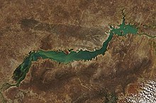
356:. The reservoir measures approximately 320 km (200 mi) long, 4,214 km (1,627 sq mi) in surface area, and a storage capacity of 34.1 km (8.2 cu mi) at its nominal elevation of 392.5 m (1,287.7 ft), making it the 15th largest reservoir (artificial lake) in the world. The lake encloses the waters of the
375:
resources of the
Northeast of Brazil, has conditions to guarantee the power supply for the region for two years but its water level is highly variable. In some drought years the energy supply is threatened.
173:
551:
385:
61:
512:
407:
536:
118:
459:
83:
54:
505:
393:
531:
541:
498:
20:
44:
402:
48:
40:
363:
452:
65:
486:
433:
357:
226:
212:
219:
8:
372:
333:
304:
546:
205:
445:
345:
147:
397:
482:
429:
243:
233:
525:
188:
175:
105:
390:
206:
220:
341:
474:
349:
249:
159:
353:
421:
367:
A Satellite picture of
Sobradinho Reservoir in August 2018.
481:
This article about a
Brazilian building or structure is a
360:, one of the largest and most important rivers in Brazil.
523:
166:
53:but its sources remain unclear because it lacks
506:
453:
371:The reservoir, which represents 60.4% of the
125:
428:This article about a dam or floodgate is a
513:
499:
460:
446:
408:Official site of city of Sobradinho, Bahia
238:498,425 km (192,443 sq mi)
84:Learn how and when to remove this message
362:
552:Brazilian building and structure stubs
524:
271:4,214 km (1,627 sq mi)
469:
416:
25:
13:
14:
563:
379:
473:
420:
152:
124:
117:
104:
30:
317:392.5 m (1,287.7 ft)
1:
537:1982 establishments in Brazil
386:Lago Artificial de Sobradinho
485:. You can help Knowledge by
432:. You can help Knowledge by
7:
295:34,100,000,000 m (1.20
21:Sobradinho (disambiguation)
10:
568:
468:
415:
18:
16:Reservoir in Bahia, Brazil
403:Hidrovia de São Francisco
321:
313:
303:
291:
283:
279:8.6 m (28.2 ft)
275:
267:
263:
255:
242:
232:
218:
204:
165:
143:
112:
103:
98:
39:This article includes a
68:more precise citations.
368:
337:
287:30 m (98 ft)
366:
532:Reservoirs in Brazil
330:Sobradinho Reservoir
189:9.36667°S 40.90000°W
132:Sobradinho Reservoir
99:Sobradinho Reservoir
19:For other uses, see
373:hydroelectric power
358:São Francisco River
305:Residence time
299:10 cu ft)
227:São Francisco River
213:São Francisco River
194:-9.36667; -40.90000
185: /
542:Landforms of Bahia
396:2009-01-07 at the
369:
338:Lago de Sobradinho
41:list of references
494:
493:
441:
440:
325:
324:
314:Surface elevation
94:
93:
86:
559:
515:
508:
501:
477:
470:
462:
455:
448:
424:
417:
298:
222:
221:Primary outflows
208:
200:
199:
197:
196:
195:
190:
186:
183:
182:
181:
178:
168:
158:
156:
155:
128:
127:
121:
108:
96:
95:
89:
82:
78:
75:
69:
64:this article by
55:inline citations
34:
33:
26:
567:
566:
562:
561:
560:
558:
557:
556:
522:
521:
520:
519:
467:
466:
413:
398:Wayback Machine
391:Sobradinho lock
382:
348:, north of the
327:
296:
246: countries
207:Primary inflows
193:
191:
187:
184:
179:
176:
174:
172:
171:
153:
151:
139:
138:
137:
136:
135:
134:
133:
129:
90:
79:
73:
70:
59:
45:related reading
35:
31:
24:
17:
12:
11:
5:
565:
555:
554:
549:
544:
539:
534:
518:
517:
510:
503:
495:
492:
491:
478:
465:
464:
457:
450:
442:
439:
438:
425:
411:
410:
405:
400:
388:
381:
380:External links
378:
323:
322:
319:
318:
315:
311:
310:
307:
301:
300:
293:
289:
288:
285:
281:
280:
277:
273:
272:
269:
265:
264:
261:
260:
257:
253:
252:
247:
240:
239:
236:
234:Catchment area
230:
229:
224:
216:
215:
210:
202:
201:
169:
163:
162:
145:
141:
140:
131:
130:
123:
122:
116:
115:
114:
113:
110:
109:
101:
100:
92:
91:
74:September 2018
49:external links
38:
36:
29:
15:
9:
6:
4:
3:
2:
564:
553:
550:
548:
545:
543:
540:
538:
535:
533:
530:
529:
527:
516:
511:
509:
504:
502:
497:
496:
490:
488:
484:
479:
476:
472:
471:
463:
458:
456:
451:
449:
444:
443:
437:
435:
431:
426:
423:
419:
418:
414:
409:
406:
404:
401:
399:
395:
392:
389:
387:
384:
383:
377:
374:
365:
361:
359:
355:
351:
347:
343:
340:) is a large
339:
335:
331:
320:
316:
312:
308:
306:
302:
294:
290:
286:
282:
278:
276:Average depth
274:
270:
266:
262:
258:
256:First flooded
254:
251:
248:
245:
241:
237:
235:
231:
228:
225:
223:
217:
214:
211:
209:
203:
198:
170:
164:
161:
149:
146:
142:
120:
111:
107:
102:
97:
88:
85:
77:
67:
63:
57:
56:
50:
46:
42:
37:
28:
27:
22:
487:expanding it
480:
434:expanding it
427:
412:
370:
329:
326:
292:Water volume
268:Surface area
80:
71:
60:Please help
52:
344:located in
192: /
167:Coordinates
66:introducing
526:Categories
346:Sobradinho
334:Portuguese
309:0.35 years
284:Max. depth
180:40°54′00″W
177:09°22′00″S
148:Sobradinho
547:Dam stubs
352:state of
350:Brazilian
342:reservoir
394:Archived
144:Location
62:improve
250:Brazil
160:Brazil
157:
354:Bahia
244:Basin
47:, or
483:stub
430:stub
328:The
259:1982
528::
336::
150:,
51:,
43:,
514:e
507:t
500:v
489:.
461:e
454:t
447:v
436:.
332:(
297:×
87:)
81:(
76:)
72:(
58:.
23:.
Text is available under the Creative Commons Attribution-ShareAlike License. Additional terms may apply.


