218:
230:
254:
242:
864:
40:
197:
On 11 July 1960, a few days after the Congo
Republic had gained independence, the province of Katanga seceded as an independent state. In November 1961 the northern portion was reconquered by the national government and made the province of Nord-Katanga (Tanganika). On 21 January 1963 the remainder
149:
The original four provinces of the
Belgian Congo had considerable autonomy, but in 1933 they were reorganized into six provinces, named after their capitals, and the central government assumed more control. Katanga became
198:
of
Katanga was reconquered and divided into the provinces of Lualaba and Katanga Oriental. Nord-Katanga, Lualaba and Katanga Oriental were merged back into the province of Katanga on 28 December 1966. In 2015 the current
217:
506:
229:
189:
to the west. The area was 135,000 square kilometres (52,000 sq mi) out of a total of 496,700 square kilometres (191,800 sq mi) for
Katanga province as a whole.
499:
492:
253:
241:
516:
275:
118:
863:
53:
39:
1209:
1214:
831:
399:
853:
520:
484:
126:
417:"Les nouvelles provinces de la République Démocratique du Congo : construction territoriale et ethnicités"
270:
103:
166:
1140:
151:
590:
861:
697:
178:
389:
1067:
846:
702:
467:
162:
1111:
1015:
917:
707:
608:
182:
598:
8:
613:
575:
570:
547:
199:
134:
416:
892:
796:
783:
775:
740:
669:
1169:
1164:
1135:
1125:
1101:
1091:
1086:
1081:
1076:
1052:
912:
822:
791:
552:
529:
395:
377:
174:
514:
1184:
1174:
1159:
1130:
1120:
1057:
1047:
1038:
1010:
1001:
975:
867:
839:
761:
745:
735:
692:
687:
679:
664:
659:
628:
618:
603:
428:
186:
170:
165:
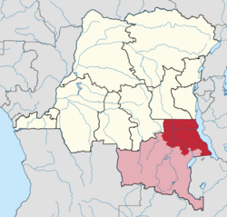
districts in the east. Tanganika
District was formed from the northern part of the
158:
122:
96:
1096:
946:
806:
580:
537:
433:
1179:
801:
651:
641:
636:
542:
1203:
965:
730:
381:
130:
68:
55:
376:(in French and Dutch), Belgium: Institut Royal Colonial Belge, 1948–1963,
138:
882:
816:
769:
897:
562:
352:
350:
980:
902:
722:
448:
1026:
932:
755:
347:
203:
133:. At its greatest extent it roughly corresponded to the present
970:
956:
941:
922:
907:
311:
223:
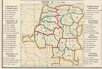
1926 provinces and districts. Katanga divided into districts
154:. The number of districts in the colony was reduced to 15.
299:
202:
was created from the
Tanganika District, whose town of
447:
356:
169:. A 1955–1957 map shows Tanganika District bordering
18:
District in
Katanga, Democratic Republic of the Congo
472:, University of California Press, GGKEY:TQ2J84FWCXN
335:
323:
287:
372:
317:
206:was elevated to capital city of the new province.
44:Tanganyika district within Katanga province (2014)
374:Atlas général du Congo / Algemene atlas van Congo
276:Districts of the Democratic Republic of the Congo
1201:
177:to the north, British territories to the east,
137:, with a small portion in the southwest now in
129:. The district dates back to the days of the
847:
500:
854:
840:
507:
493:
465:
305:
432:
157:Elisabethville Province was divided into
469:Political Awakening in the Belgian Congo
414:
293:
1202:
835:
488:
415:Bruneau, Jean-Claude (30 June 2009),
387:
341:
329:
192:
13:
388:Brass, William (8 December 2015),
14:
1226:
862:
521:Democratic Republic of the Congo
259:The current Haut-Lomami Province
252:
240:
228:
216:
144:
127:Democratic Republic of the Congo
88:Democratic Republic of the Congo
38:
247:The current Tanganyika Province
161:in the west, and Tanganika and
1210:Districts of the Belgian Congo
394:, Princeton University Press,
271:Districts of the Belgian Congo
235:1933 provinces and districts.
1:
1215:Districts of Katanga Province
391:Demography of Tropical Africa
281:
449:"Congo (Kinshasa) Provinces"
434:10.4000/espacepolitique.1296
7:
264:
10:
1231:
365:
357:Congo (Kinshasa) Provinces
209:
1149:
1110:
1066:
1037:
1032:(see the district, above)
1024:
1000:
994:Districts and territories
993:
955:
931:
881:
874:
815:
782:
768:
754:
721:
678:
650:
627:
589:
561:
528:
466:Lemarchand, René (1964),
102:
92:
84:
49:
37:
30:
23:
167:Tanganika-Moero District
152:Elisabethville Province
318:Atlas général du Congo
179:Luapula-Moero District
1068:Haut-Katanga District
185:to the southwest and
1112:Haut-Lomami District
183:Haut-Lomami District
875:Cities and communes
200:Tanganyika Province
135:Tanganyika Province
65: /
1151:Tanganika District
421:L'Espace Politique
115:Tanganika District
108:Tanganika District
25:Tanganika District
1197:
1196:
1193:
1192:
989:
988:
829:
828:
401:978-1-4008-7714-0
193:Post-Independence
175:Sud-Kivu District
112:
111:
69:5.916667°S 29.2°E
1222:
1039:Lualaba District
1002:Kolwezi District
998:
997:
879:
878:
868:Katanga Province
866:
856:
849:
842:
833:
832:
629:Kasai-Occidental
509:
502:
495:
486:
485:
480:
479:
477:
462:
461:
459:
444:
443:
441:
436:
411:
410:
408:
384:
360:
354:
345:
339:
333:
327:
321:
315:
309:
303:
297:
291:
256:
244:
232:
220:
187:Kabinda District
171:Maniema District
159:Lualaba District
123:Katanga Province
121:of the pre-2015
80:
79:
77:
76:
75:
70:
66:
63:
62:
61:
58:
42:
21:
20:
1230:
1229:
1225:
1224:
1223:
1221:
1220:
1219:
1200:
1199:
1198:
1189:
1145:
1106:
1062:
1033:
1020:
985:
951:
927:
870:
860:
830:
825:
811:
778:
764:
750:
717:
674:
646:
623:
585:
557:
524:
513:
483:
475:
473:
457:
455:
439:
437:
406:
404:
402:
368:
363:
355:
348:
340:
336:
328:
324:
316:
312:
306:Lemarchand 1964
304:
300:
292:
288:
284:
267:
260:
257:
248:
245:
236:
233:
224:
221:
212:
195:
147:
74:-5.916667; 29.2
73:
71:
67:
64:
59:
56:
54:
52:
51:
45:
33:
26:
19:
12:
11:
5:
1228:
1218:
1217:
1212:
1195:
1194:
1191:
1190:
1188:
1187:
1182:
1177:
1172:
1167:
1162:
1155:
1153:
1147:
1146:
1144:
1143:
1138:
1133:
1128:
1123:
1116:
1114:
1108:
1107:
1105:
1104:
1099:
1094:
1089:
1084:
1079:
1072:
1070:
1064:
1063:
1061:
1060:
1055:
1050:
1043:
1041:
1035:
1034:
1031:
1029:
1022:
1021:
1019:
1018:
1013:
1006:
1004:
995:
991:
990:
987:
986:
984:
983:
978:
973:
968:
961:
959:
953:
952:
950:
949:
944:
937:
935:
929:
928:
926:
925:
920:
915:
910:
905:
900:
895:
888:
886:
876:
872:
871:
859:
858:
851:
844:
836:
827:
826:
821:
819:
813:
812:
810:
809:
804:
799:
794:
788:
786:
780:
779:
774:
772:
766:
765:
760:
758:
752:
751:
749:
748:
743:
738:
733:
727:
725:
719:
718:
716:
715:
710:
705:
700:
695:
690:
684:
682:
676:
675:
673:
672:
667:
662:
656:
654:
652:Kasai-Oriental
648:
647:
645:
644:
639:
633:
631:
625:
624:
622:
621:
616:
611:
606:
601:
595:
593:
587:
586:
584:
583:
578:
573:
567:
565:
559:
558:
556:
555:
550:
545:
540:
534:
532:
526:
525:
512:
511:
504:
497:
489:
482:
481:
463:
445:
412:
400:
385:
369:
367:
364:
362:
361:
346:
344:, p. 254.
334:
332:, p. 243.
322:
310:
298:
285:
283:
280:
279:
278:
273:
266:
263:
262:
261:
258:
251:
249:
246:
239:
237:
234:
227:
225:
222:
215:
211:
208:
194:
191:
181:to the south,
146:
143:
110:
109:
106:
100:
99:
94:
90:
89:
86:
82:
81:
47:
46:
43:
35:
34:
31:
28:
27:
24:
17:
9:
6:
4:
3:
2:
1227:
1216:
1213:
1211:
1208:
1207:
1205:
1186:
1183:
1181:
1178:
1176:
1173:
1171:
1168:
1166:
1163:
1161:
1158:Territories:
1157:
1156:
1154:
1152:
1148:
1142:
1141:Malemba-Nkulu
1139:
1137:
1134:
1132:
1129:
1127:
1124:
1122:
1118:
1117:
1115:
1113:
1109:
1103:
1100:
1098:
1095:
1093:
1090:
1088:
1085:
1083:
1080:
1078:
1074:
1073:
1071:
1069:
1065:
1059:
1056:
1054:
1051:
1049:
1046:Territories:
1045:
1044:
1042:
1040:
1036:
1030:
1028:
1023:
1017:
1014:
1012:
1009:Territories:
1008:
1007:
1005:
1003:
999:
996:
992:
982:
979:
977:
974:
972:
969:
967:
963:
962:
960:
958:
954:
948:
945:
943:
939:
938:
936:
934:
930:
924:
921:
919:
916:
914:
911:
909:
906:
904:
901:
899:
896:
894:
890:
889:
887:
884:
880:
877:
873:
869:
865:
857:
852:
850:
845:
843:
838:
837:
834:
824:
820:
818:
814:
808:
805:
803:
800:
798:
795:
793:
790:
789:
787:
785:
781:
777:
773:
771:
767:
763:
759:
757:
753:
747:
744:
742:
739:
737:
734:
732:
729:
728:
726:
724:
720:
714:
711:
709:
706:
704:
701:
699:
698:Luapula-Moero
696:
694:
691:
689:
686:
685:
683:
681:
677:
671:
668:
666:
663:
661:
658:
657:
655:
653:
649:
643:
640:
638:
635:
634:
632:
630:
626:
620:
617:
615:
612:
610:
607:
605:
602:
600:
597:
596:
594:
592:
588:
582:
579:
577:
574:
572:
569:
568:
566:
564:
560:
554:
551:
549:
546:
544:
541:
539:
536:
535:
533:
531:
527:
522:
518:
510:
505:
503:
498:
496:
491:
490:
487:
471:
470:
464:
454:
450:
446:
435:
430:
426:
422:
418:
413:
403:
397:
393:
392:
386:
383:
379:
375:
371:
370:
358:
353:
351:
343:
338:
331:
326:
319:
314:
308:, p. 64.
307:
302:
295:
290:
286:
277:
274:
272:
269:
268:
255:
250:
243:
238:
231:
226:
219:
214:
213:
207:
205:
201:
190:
188:
184:
180:
176:
172:
168:
164:
160:
155:
153:
145:Belgian Congo
142:
140:
136:
132:
131:Belgian Congo
128:
124:
120:
116:
107:
105:
101:
98:
95:
91:
87:
83:
78:
50:Coordinates:
48:
41:
36:
29:
22:
16:
1150:
1119:Territories:
1075:Territories:
712:
703:Haut-Katanga
474:, retrieved
468:
456:, retrieved
452:
438:, retrieved
424:
420:
405:, retrieved
390:
373:
337:
325:
313:
301:
296:, p. 8.
294:Bruneau 2009
289:
196:
163:Haut-Katanga
156:
148:
114:
113:
15:
708:Haut-Lomami
609:Nord-Ubangi
139:Haut-Lomami
72: /
1204:Categories
1016:Mutshatsha
940:Communes:
918:Lubumbashi
891:Communes:
883:Lubumbashi
817:South Kivu
770:North Kivu
614:Sud-Ubangi
576:Cataractes
571:Bas-Fleuve
548:Mai-Ndombe
453:Rulers.org
427:(2009–1),
342:Brass 2015
330:Brass 2015
282:References
141:Province.
60:29°12′00″E
964:Communes:
898:Kamalondo
885:(capital)
797:Haut-Uele
784:Orientale
776:Nord Kivu
741:Mont Amba
713:Tanganika
670:Tshilenge
563:Bas-Congo
517:Districts
476:19 August
407:20 August
382:681334449
57:5°55′00″S
1025:City of
981:Tshituru
903:Kampemba
823:Sud-Kivu
792:Bas-Uele
723:Kinshasa
599:Équateur
591:Équateur
553:Plateaux
530:Bandundu
458:5 August
440:8 August
265:See also
119:district
104:District
93:Province
32:District
1170:Kongolo
1165:Kalemie
1136:Kanyama
1126:Kabongo
1102:Sakania
1092:Mitwaba
1087:Kipushi
1082:Kasenga
1077:Kambove
1053:Kapanga
1027:Kolwezi
933:Kolwezi
762:Maniema
756:Maniema
746:Tshangu
736:Lukunga
693:Lualaba
688:Kolwezi
680:Katanga
665:Sankuru
660:Kabinda
619:Tshuapa
604:Mongala
523:(–2015)
519:of the
515:Former
366:Sources
210:Gallery
204:Kalemie
125:in the
97:Katanga
85:Country
1185:Nyunzu
1175:Manono
1160:Kabalo
1131:Kamina
1121:Bukama
1058:Sandoa
1048:Dilolo
1011:Lubudi
976:Likasi
971:Kikula
957:Likasi
947:Manika
942:Dilala
923:Rwashi
908:Katuba
893:Annexe
807:Tshopo
581:Lukaya
538:Kwango
398:
380:
117:was a
1097:Pweto
966:Panda
913:Kenya
802:Ituri
642:Lulua
637:Kasai
543:Kwilu
1180:Moba
731:Funa
478:2020
460:2020
442:2020
409:2020
396:ISBN
378:OCLC
173:and
429:doi
1206::
451:,
423:,
419:,
349:^
855:e
848:t
841:v
508:e
501:t
494:v
431::
425:7
359:.
320:.
Text is available under the Creative Commons Attribution-ShareAlike License. Additional terms may apply.


