194:
240:
232:
31:
1996:
2265:
248:
1554:
591:
221:
2277:
302:
Flakes, rejects and part-finished axes have been found round the hill and peak. It was here that the axes were roughed out before being finished at the sea shore. They were then exported as far afield as south-west
Ireland, south-east
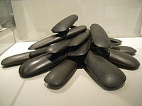
330:. Some of the axes were inserted upright in the ground. The axes may be too big and heavy for practical use, so perhaps were meant to be used for ceremonial purposes. They are currently held in the
124:
2295:
1493:
482:
1916:
212:, which is found at the foot of the eastern scree slope of the mountain. Three small outcrops of porcellanite can be seen on the higher south-east slope.
2354:
178:
2334:
601:
2344:
2249:
390:
2349:
1486:
1909:
174:
350:
536:
1479:
1440:
2339:
1902:
137:
1110:
470:
2213:
2115:
1804:
556:
2077:
1512:
1445:
2228:
193:
1349:
529:
118:
200:
layer is the black rock above the hammer, and below the brown layer higher up the slope at
Tievebulliagh
2193:
2015:
985:
614:
1065:
685:
395:
239:
1955:
1570:
1249:
1208:
1203:
1100:
1095:
1015:
1010:
855:
780:
208:, the intense heat generated by molten basalt has given rise to the formation of a durable flint,
2281:
1450:
1035:
1000:
995:
990:
1626:
1377:
830:
565:
522:
354:
56:
35:
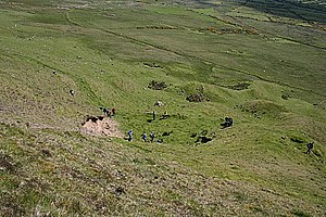
Tievebulliagh, May 2007. Fragments of porcellanite can be seen among the dolerite in the scree.
251:
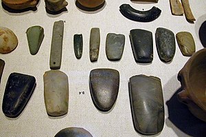
An array of
Neolithic artifacts, including bracelets, axe heads, chisels, and polishing tools.
1455:
1279:
1188:
609:
284:
280:
493:
2067:
1641:
1618:
1600:
1213:
910:
810:
690:
231:
8:
2183:
1975:
1853:
1824:
1329:
1269:
2359:
1945:
69:
450:
1694:
1030:
705:
700:
466:
439:
30:
2178:
2170:
2135:
2105:
2087:
1970:
1929:
1848:
1751:
1723:
1708:
1417:
1412:
1143:
935:
890:
166:
93:
2125:
1736:
1646:
1520:
1274:
400:
162:
132:
111:
1471:
2269:
2150:
2130:
2120:
2054:
2050:
2035:
2030:
1985:
1878:
1814:
1809:
1756:
1746:
1460:
1309:
1304:
1040:
323:
268:
225:
153:
107:
100:
74:
1894:
2328:
2310:
2297:
2218:
2203:
2145:
2007:
1883:
1832:
1771:
1766:
1679:
1402:
1397:
1392:
1387:
1382:
1372:
1367:
1239:
1168:
1080:
920:
750:
634:
546:
366:
331:
264:
205:
89:
2233:
2223:
2208:
2140:
1980:
1873:
1868:
1761:
1684:
1362:
1357:
1339:
1289:
1244:
1090:
980:
955:
795:
644:
370:
345:
axe factory on
Tievebulliagh are Scheduled Historic Monuments sited in the
319:
260:
224:
The Malone hoard of polished axes made from material from
Tievebulliagh or
209:
197:
170:
1995:
514:
2198:
2155:
2110:
2100:
2072:
1799:
1776:
1713:
1590:
1427:
1422:
1324:
1294:
1284:
1193:
1178:
1173:
1163:
1133:
1123:
1050:
1045:
925:
835:
825:
815:
770:
745:
735:
730:
725:
695:
654:
374:
292:
288:
259:
axe quarry at the foot of
Tievebulliagh. Flint axe heads fashioned from
247:
2095:
2020:
1950:
1794:
1741:
1703:
1636:
1608:
1538:
1314:
1223:
1198:
1138:
1025:
1005:
975:
965:
945:
940:
870:
840:
800:
785:
765:
720:
670:
629:
619:
362:
338:
182:
2264:
2062:
1937:
1863:
1671:
1631:
1580:
1553:
1407:
1299:
1264:
1218:
1153:
1148:
1118:
1075:
1060:
1055:
1020:
970:
915:
845:
805:
760:
740:
715:
710:
624:
378:
358:
342:
315:
296:
256:
2188:
2160:
1960:
1858:
1786:
1731:
1656:
1575:
1254:
1158:
960:
865:
755:
680:
649:
346:
308:
490:
Environment and
Heritage Service NI - Scheduled Historic Monuments
2025:
1925:
1661:
1651:
1562:
1543:
1528:
1319:
1183:
1128:
950:
930:
900:
895:
880:
875:
850:
675:
579:
573:
327:
304:
276:
272:
1503:
1070:
905:
885:
790:
775:
46:
590:
220:
1965:
1585:
1259:
1085:
860:
820:
639:
263:
that originate from this quarry have been found across the
357:
area, at grid ref: area of D193 266. There are numerous
311:. No finished axes have been found at the site itself.
161:) is a 402-metre-high (1,319 ft) mountain in the
326:, was found at Danesfort house, on the Malone Road,
181:
to the south. It is situated about 4.4 km from
322:Tievebulliagh or similar material from Brockley on
1501:
2326:
235:view of the hillocks at the base of the mountain
1924:
341:cairn on the mountain top. The round cairn and
314:The "Malone Hoard", consisting of 19 polished
1910:
1487:
530:
391:List of archaeological sites in County Antrim
544:
156:
1917:
1903:
1494:
1480:
537:
523:
1994:
429:. Belfast: Blackstaff Press. p. 96.
246:
238:
230:
219:
192:
2355:Scheduled monuments in Northern Ireland
424:
2327:
2335:Archaeological sites in County Antrim
2250:Geological faults of Northern Ireland
1898:
1475:
518:
2345:Mountains and hills of County Antrim
420:
418:
416:
255:Evidence has been discovered of a
13:
2350:Volcanic plugs of Northern Ireland
1999:Basalt columns at Giant's Causeway
589:
243:View from the peak of the mountain
14:
2371:
413:
2275:
2263:
1552:
29:
557:List of places in County Antrim
204:Tievebulliagh is formed from a
24:Tievebulliagh (Taobh Builleach)
475:
455:
444:
433:
215:
1:
1513:Lists of mountains in Ireland
465:. Blackstaff Press. Belfast.
406:
365:monuments in the vicinity in
279:. The site compares with the
2340:Marilyns of Northern Ireland
2229:Ulster White Limestone Group
1441:WikiProject Northern Ireland
427:Early Ireland. A Field Guide
18:Mountain in Northern Ireland
7:
2282:Northern Ireland portal
384:
10:
2376:
2194:Hibernian Greensands Group
1550:
188:
51:402 m (1,319 ft)
2258:
2242:
2169:
2086:
2049:
2006:
1992:
1936:
1841:
1823:
1785:
1722:
1693:
1670:
1617:
1599:
1561:
1519:
1510:
1436:
1348:
1232:
1109:
663:
600:
587:
564:
553:
396:List of hoards in Ireland
295:, where large numbers of
131:
117:
99:
85:
80:
68:
55:
45:
40:
28:
23:
483:"Cloghs (Tievebulliagh)"
1502:Mountains and hills of
1451:Northern Ireland Portal
275:and across the rest of
169:. It forms part of the
2000:
594:
355:Moyle District Council
271:to the south coast of
252:
244:
236:
228:
201:
157:
1998:
1456:United Kingdom Portal
1280:Glenariff Forest Park
593:
451:The Megalithic Portal
285:English Lake District
281:Langdale axe industry
250:
242:
234:
223:
196:
2311:55.07419°N 6.13302°W
1642:Ardloughnabrackbaddy
287:and the quarries at
2307: /
2184:Benaughlin Mountain
1446:WikiProject Ireland
1330:Slieveanorra Forest
299:were manufactured.
2316:55.07419; -6.13302
2270:Geology portal
2001:
595:
499:on 5 November 2008
253:
245:
237:
229:
202:
41:Highest point
2290:
2289:
2214:Marble Arch Caves
1892:
1891:
1825:Southwest Donegal
1469:
1468:
1031:Newtown Crommelin
706:Ballinderry Lower
701:Ballinderry Upper
461:Viney, M. (2003)
177:to the north and
147:
146:
2367:
2322:
2321:
2319:
2318:
2317:
2312:
2308:
2305:
2304:
2303:
2300:
2280:
2279:
2278:
2268:
2267:
2179:Belmore Mountain
2136:Slieve Commedagh
2106:Mourne Mountains
1976:Giant's Causeway
1930:Northern Ireland
1919:
1912:
1905:
1896:
1895:
1849:Belmore Mountain
1752:Slieve Commedagh
1556:
1496:
1489:
1482:
1473:
1472:
1418:Massereene Upper
1413:Massereene Lower
1270:Giant's Causeway
1144:Broomhedge Lower
936:Kells and Connor
539:
532:
525:
516:
515:
509:
508:
506:
504:
498:
492:. Archived from
487:
479:
473:
459:
453:
448:
442:
437:
431:
430:
425:Weir, A (1980).
422:
167:Northern Ireland
160:
127:
103:
94:Northern Ireland
33:
21:
20:
2375:
2374:
2370:
2369:
2368:
2366:
2365:
2364:
2325:
2324:
2315:
2313:
2309:
2306:
2301:
2298:
2296:
2294:
2293:
2291:
2286:
2276:
2274:
2262:
2254:
2238:
2165:
2126:Slieve Bearnagh
2082:
2068:Ring of Gullion
2045:
2002:
1990:
1932:
1923:
1893:
1888:
1837:
1819:
1781:
1737:Slieve Bearnagh
1718:
1689:
1666:
1647:Crocknalaragagh
1613:
1595:
1557:
1548:
1515:
1506:
1500:
1470:
1465:
1432:
1344:
1275:Glens of Antrim
1228:
1105:
659:
596:
585:
560:
549:
543:
513:
512:
502:
500:
496:
485:
481:
480:
476:
460:
456:
449:
445:
440:Habitas Website
438:
434:
423:
414:
409:
401:Glens of Antrim
387:
307:and north-east
218:
191:
163:Glens of Antrim
158:Taobh Builleach
123:
112:Glens of Antrim
101:
36:
19:
12:
11:
5:
2373:
2363:
2362:
2357:
2352:
2347:
2342:
2337:
2288:
2287:
2285:
2284:
2272:
2259:
2256:
2255:
2253:
2252:
2246:
2244:
2240:
2239:
2237:
2236:
2231:
2226:
2221:
2216:
2211:
2206:
2201:
2196:
2191:
2186:
2181:
2175:
2173:
2167:
2166:
2164:
2163:
2158:
2153:
2151:Slieve Gallion
2148:
2143:
2138:
2133:
2131:Slieve Binnian
2128:
2123:
2121:Sawel Mountain
2118:
2113:
2108:
2103:
2098:
2092:
2090:
2084:
2083:
2081:
2080:
2075:
2070:
2065:
2059:
2057:
2047:
2046:
2044:
2043:
2038:
2036:Slieve Gullion
2033:
2031:Slieve Gallion
2028:
2023:
2018:
2016:Carrick a Rede
2012:
2010:
2008:Volcanic plugs
2004:
2003:
1993:
1991:
1989:
1988:
1986:Rathlin Island
1983:
1978:
1973:
1968:
1963:
1958:
1956:Black Mountain
1953:
1948:
1946:Antrim plateau
1942:
1940:
1934:
1933:
1922:
1921:
1914:
1907:
1899:
1890:
1889:
1887:
1886:
1881:
1879:Slieve Gullion
1876:
1871:
1866:
1861:
1856:
1851:
1845:
1843:
1839:
1838:
1836:
1835:
1829:
1827:
1821:
1820:
1818:
1817:
1815:Slieve Gallion
1812:
1807:
1802:
1797:
1791:
1789:
1783:
1782:
1780:
1779:
1774:
1769:
1764:
1759:
1757:Slieve Corragh
1754:
1749:
1747:Slieve Binnian
1744:
1739:
1734:
1728:
1726:
1720:
1719:
1717:
1716:
1711:
1706:
1700:
1698:
1691:
1690:
1688:
1687:
1682:
1676:
1674:
1668:
1667:
1665:
1664:
1659:
1654:
1649:
1644:
1639:
1634:
1629:
1623:
1621:
1615:
1614:
1612:
1611:
1605:
1603:
1597:
1596:
1594:
1593:
1588:
1583:
1578:
1573:
1571:Black Mountain
1567:
1565:
1559:
1558:
1551:
1549:
1547:
1546:
1541:
1536:
1531:
1525:
1523:
1517:
1516:
1511:
1508:
1507:
1499:
1498:
1491:
1484:
1476:
1467:
1466:
1464:
1463:
1461:Ireland Portal
1458:
1453:
1448:
1443:
1437:
1434:
1433:
1431:
1430:
1425:
1420:
1415:
1410:
1405:
1400:
1395:
1390:
1385:
1380:
1375:
1370:
1365:
1360:
1354:
1352:
1346:
1345:
1343:
1342:
1337:
1332:
1327:
1322:
1317:
1312:
1310:Rathlin Island
1307:
1305:Portmore Lough
1302:
1297:
1292:
1287:
1282:
1277:
1272:
1267:
1262:
1257:
1252:
1250:Black Mountain
1247:
1242:
1236:
1234:
1230:
1229:
1227:
1226:
1221:
1216:
1211:
1206:
1201:
1196:
1191:
1186:
1181:
1176:
1171:
1166:
1161:
1156:
1151:
1146:
1141:
1136:
1131:
1126:
1121:
1115:
1113:
1107:
1106:
1104:
1103:
1098:
1093:
1088:
1083:
1078:
1073:
1068:
1063:
1058:
1053:
1048:
1043:
1041:Portballintrae
1038:
1033:
1028:
1023:
1018:
1013:
1008:
1003:
998:
993:
988:
983:
978:
973:
968:
963:
958:
953:
948:
943:
938:
933:
928:
923:
918:
913:
908:
903:
898:
893:
888:
883:
878:
873:
868:
863:
858:
853:
848:
843:
838:
833:
828:
823:
821:Cogry-Kilbride
818:
813:
808:
803:
798:
793:
788:
783:
778:
773:
768:
763:
758:
753:
748:
743:
738:
733:
728:
723:
718:
713:
708:
703:
698:
693:
688:
683:
678:
673:
667:
665:
661:
660:
658:
657:
652:
647:
642:
637:
632:
627:
622:
617:
612:
606:
604:
598:
597:
588:
586:
584:
583:
577:
570:
568:
562:
561:
554:
551:
550:
542:
541:
534:
527:
519:
511:
510:
474:
454:
443:
432:
411:
410:
408:
405:
404:
403:
398:
393:
386:
383:
369:, and include
324:Rathlin Island
269:Outer Hebrides
226:Rathlin Island
217:
214:
190:
187:
145:
144:
135:
129:
128:
121:
115:
114:
108:Antrim Plateau
105:
97:
96:
87:
83:
82:
78:
77:
72:
66:
65:
59:
53:
52:
49:
43:
42:
38:
37:
34:
26:
25:
17:
9:
6:
4:
3:
2:
2372:
2361:
2358:
2356:
2353:
2351:
2348:
2346:
2343:
2341:
2338:
2336:
2333:
2332:
2330:
2323:
2320:
2283:
2273:
2271:
2266:
2261:
2260:
2257:
2251:
2248:
2247:
2245:
2241:
2235:
2232:
2230:
2227:
2225:
2222:
2220:
2219:Slieve Rushen
2217:
2215:
2212:
2210:
2207:
2205:
2204:Leitrim Group
2202:
2200:
2197:
2195:
2192:
2190:
2187:
2185:
2182:
2180:
2177:
2176:
2174:
2172:
2168:
2162:
2159:
2157:
2154:
2152:
2149:
2147:
2146:Slieve Donard
2144:
2142:
2139:
2137:
2134:
2132:
2129:
2127:
2124:
2122:
2119:
2117:
2114:
2112:
2109:
2107:
2104:
2102:
2099:
2097:
2094:
2093:
2091:
2089:
2085:
2079:
2076:
2074:
2071:
2069:
2066:
2064:
2061:
2060:
2058:
2056:
2052:
2048:
2042:
2041:Tievebulliagh
2039:
2037:
2034:
2032:
2029:
2027:
2024:
2022:
2019:
2017:
2014:
2013:
2011:
2009:
2005:
1997:
1987:
1984:
1982:
1979:
1977:
1974:
1972:
1971:Donald's Hill
1969:
1967:
1964:
1962:
1959:
1957:
1954:
1952:
1949:
1947:
1944:
1943:
1941:
1939:
1935:
1931:
1927:
1920:
1915:
1913:
1908:
1906:
1901:
1900:
1897:
1885:
1884:Slieve Rushen
1882:
1880:
1877:
1875:
1872:
1870:
1867:
1865:
1862:
1860:
1857:
1855:
1852:
1850:
1847:
1846:
1844:
1840:
1834:
1833:Slieve League
1831:
1830:
1828:
1826:
1822:
1816:
1813:
1811:
1808:
1806:
1803:
1801:
1798:
1796:
1793:
1792:
1790:
1788:
1784:
1778:
1775:
1773:
1772:Slievelamagan
1770:
1768:
1767:Slieve Donard
1765:
1763:
1760:
1758:
1755:
1753:
1750:
1748:
1745:
1743:
1740:
1738:
1735:
1733:
1730:
1729:
1727:
1725:
1721:
1715:
1712:
1710:
1709:Donald's Hill
1707:
1705:
1702:
1701:
1699:
1696:
1692:
1686:
1683:
1681:
1680:Slieve Snaght
1678:
1677:
1675:
1673:
1669:
1663:
1660:
1658:
1655:
1653:
1650:
1648:
1645:
1643:
1640:
1638:
1635:
1633:
1630:
1628:
1627:Seven Sisters
1625:
1624:
1622:
1620:
1616:
1610:
1607:
1606:
1604:
1602:
1598:
1592:
1589:
1587:
1584:
1582:
1579:
1577:
1574:
1572:
1569:
1568:
1566:
1564:
1563:Belfast Hills
1560:
1555:
1545:
1542:
1540:
1537:
1535:
1534:Tievebulliagh
1532:
1530:
1527:
1526:
1524:
1522:
1518:
1514:
1509:
1505:
1497:
1492:
1490:
1485:
1483:
1478:
1477:
1474:
1462:
1459:
1457:
1454:
1452:
1449:
1447:
1444:
1442:
1439:
1438:
1435:
1429:
1426:
1424:
1421:
1419:
1416:
1414:
1411:
1409:
1406:
1404:
1403:Glenarm Upper
1401:
1399:
1398:Glenarm Lower
1396:
1394:
1393:Dunluce Upper
1391:
1389:
1388:Dunluce Lower
1386:
1384:
1381:
1379:
1378:Carrickfergus
1376:
1374:
1373:Belfast Upper
1371:
1369:
1368:Belfast Lower
1366:
1364:
1361:
1359:
1356:
1355:
1353:
1351:
1347:
1341:
1338:
1336:
1335:Tievebulliagh
1333:
1331:
1328:
1326:
1323:
1321:
1318:
1316:
1313:
1311:
1308:
1306:
1303:
1301:
1298:
1296:
1293:
1291:
1288:
1286:
1283:
1281:
1278:
1276:
1273:
1271:
1268:
1266:
1263:
1261:
1258:
1256:
1253:
1251:
1248:
1246:
1243:
1241:
1240:Belfast Lough
1238:
1237:
1235:
1231:
1225:
1222:
1220:
1217:
1215:
1212:
1210:
1207:
1205:
1202:
1200:
1197:
1195:
1192:
1190:
1187:
1185:
1182:
1180:
1177:
1175:
1172:
1170:
1169:Galgorm Parks
1167:
1165:
1162:
1160:
1157:
1155:
1152:
1150:
1147:
1145:
1142:
1140:
1137:
1135:
1132:
1130:
1127:
1125:
1122:
1120:
1117:
1116:
1114:
1112:
1108:
1102:
1099:
1097:
1094:
1092:
1089:
1087:
1084:
1082:
1081:Templepatrick
1079:
1077:
1074:
1072:
1069:
1067:
1064:
1062:
1059:
1057:
1054:
1052:
1049:
1047:
1044:
1042:
1039:
1037:
1034:
1032:
1029:
1027:
1024:
1022:
1019:
1017:
1014:
1012:
1009:
1007:
1004:
1002:
999:
997:
994:
992:
989:
987:
984:
982:
979:
977:
974:
972:
969:
967:
964:
962:
959:
957:
954:
952:
949:
947:
944:
942:
939:
937:
934:
932:
929:
927:
924:
922:
921:Grange Corner
919:
917:
914:
912:
909:
907:
904:
902:
899:
897:
894:
892:
891:Gawley's Gate
889:
887:
884:
882:
879:
877:
874:
872:
869:
867:
864:
862:
859:
857:
854:
852:
849:
847:
844:
842:
839:
837:
834:
832:
829:
827:
824:
822:
819:
817:
814:
812:
809:
807:
804:
802:
799:
797:
794:
792:
789:
787:
784:
782:
779:
777:
774:
772:
769:
767:
764:
762:
759:
757:
754:
752:
751:Ballystrudder
749:
747:
744:
742:
739:
737:
734:
732:
729:
727:
724:
722:
719:
717:
714:
712:
709:
707:
704:
702:
699:
697:
694:
692:
689:
687:
684:
682:
679:
677:
674:
672:
669:
668:
666:
662:
656:
653:
651:
648:
646:
643:
641:
638:
636:
635:Carrickfergus
633:
631:
628:
626:
623:
621:
618:
616:
613:
611:
608:
607:
605:
603:
599:
592:
581:
578:
575:
572:
571:
569:
567:
563:
559:
558:
552:
548:
547:County Antrim
540:
535:
533:
528:
526:
521:
520:
517:
495:
491:
484:
478:
472:
471:0-85640-744-5
468:
464:
458:
452:
447:
441:
436:
428:
421:
419:
417:
412:
402:
399:
397:
394:
392:
389:
388:
382:
380:
376:
372:
371:stone circles
368:
367:County Antrim
364:
360:
356:
352:
348:
344:
340:
335:
333:
332:Ulster Museum
329:
325:
321:
317:
312:
310:
306:
300:
298:
294:
290:
286:
283:based in the
282:
278:
274:
270:
266:
265:British Isles
262:
258:
249:
241:
233:
227:
222:
213:
211:
207:
206:volcanic plug
199:
195:
186:
184:
180:
179:Glenballyemon
176:
172:
168:
164:
159:
155:
151:
150:Tievebulliagh
142:
139:
136:
134:
130:
126:
122:
120:
119:OSI/OSNI grid
116:
113:
109:
106:
104:
98:
95:
91:
90:County Antrim
88:
84:
79:
76:
73:
71:
67:
63:
60:
58:
54:
50:
48:
44:
39:
32:
27:
22:
16:
2292:
2234:Waterloo Bay
2224:Tyrone Group
2209:Magheramorne
2141:Slieve Croob
2078:The Skerries
2040:
1981:Murlough Bay
1874:Slieve Beagh
1869:Knock Iveagh
1762:Slieve Croob
1685:Raghtin More
1533:
1521:Antrim Hills
1363:Antrim Upper
1358:Antrim Lower
1340:Waterloo Bay
1334:
1290:Lagan Valley
1245:Benbane Head
1091:Tullynacross
981:Magheramorne
956:Knocknacarry
796:Carnalbanagh
645:Newtownabbey
555:
501:. Retrieved
494:the original
489:
477:
462:
457:
446:
435:
426:
375:long barrows
336:
334:in Belfast.
320:porcellanite
313:
301:
267:, from the
261:porcellanite
254:
210:porcellanite
203:
198:Porcellanite
149:
148:
140:
102:Parent range
61:
15:
2314: /
2199:Islandmagee
2171:Sedimentary
2156:Slieve Muck
2116:Mullaghmore
2111:Mullaghcarn
2101:Loughermore
2088:Metamorphic
2073:The Maidens
1805:Mullaghmore
1800:Mullaghcarn
1777:Slieve Muck
1714:Loughermore
1601:Blue Stacks
1591:Slieve True
1428:Toome Upper
1423:Toome Lower
1325:Slieve True
1295:Larne Lough
1285:Islandmagee
1179:Jordanstown
1174:Glengormley
1164:Dunseverick
1134:Bonnybefore
1124:Ballycraigy
1051:Portglenone
1046:Portbraddon
986:Martinstown
926:Greenisland
836:Cullybackey
826:Craigarogan
771:Broughshane
746:Ballyrobert
726:Ballyeaston
696:Aughafatten
655:Randalstown
615:Ballycastle
337:There is a
293:North Wales
289:Penmaenmawr
216:Archaeology
2329:Categories
2299:55°04′27″N
2096:Benbradagh
2021:Scawt Hill
1951:Benevenagh
1854:Benaughlin
1795:Benbradagh
1742:Slieve Beg
1704:Binevenagh
1637:Aghla More
1619:Derryveagh
1609:Croaghgorm
1539:Scawt Hill
1315:Scawt Hill
1224:Whiteabbey
1199:Loughlynch
1194:Lisnagarvy
1139:Broomhedge
1066:Stoneyford
1026:Mullaghboy
1006:Moneyglass
976:Maghaberry
966:Loughguile
946:Keshbridge
941:Kellswater
871:Drains Bay
841:Cushendall
816:Cloghmills
801:Carncastle
786:Capecastle
766:Bendooragh
736:Ballylinny
731:Ballygally
721:Ballycarry
686:Aldergrove
671:Aghagallon
630:Ballymoney
620:Ballyclare
545:Places in
503:3 December
407:References
379:stone rows
363:Bronze Age
339:Bronze Age
316:stone axes
297:stone axes
183:Cushendall
141:Discoverer
57:Prominence
2360:Neolithic
2302:6°07′59″W
2063:Fair Head
1938:Volcanism
1864:Fair Head
1672:Inishowen
1632:Aghla Beg
1581:Carnmoney
1408:Kilconway
1300:Lough Beg
1265:Fair Head
1233:Landforms
1219:Tobergill
1209:Rathcoole
1204:Monkstown
1154:Dunamuggy
1149:Carnmoney
1119:Artiforty
1111:Townlands
1101:Whitehead
1096:Waterfoot
1076:Stranocum
1061:Roughfort
1056:Rasharkin
1021:Mounthill
1016:Moss-side
1011:Monkstown
971:Lurganure
916:Gracehill
856:Derrymore
846:Cushendun
806:Carnlough
781:Bushmills
761:Balnamore
741:Ballynure
716:Ballybogy
711:Ballintoy
625:Ballymena
359:Neolithic
343:Neolithic
257:Neolithic
171:watershed
81:Geography
47:Elevation
2189:Cuilcagh
2161:Sperrins
1961:Cavehill
1859:Cuilcagh
1787:Sperrins
1732:Ben Crom
1695:Keenaght
1657:Mackoght
1576:Cavehill
1350:Baronies
1255:Cavehill
1159:Dunmurry
1036:Parkgate
1001:Milltown
996:Millbank
991:Mill Bay
961:Longkesh
866:Donegore
756:Ballyvoy
681:Ahoghill
664:Villages
650:Portrush
385:See also
347:townland
309:Scotland
173:between
133:Topo map
86:Location
2026:Slemish
1926:Geology
1724:Mournes
1662:Muckish
1652:Errigal
1544:Trostan
1529:Slemish
1320:Slemish
1184:Kilroot
1129:Barmeen
951:Killead
931:Groggan
901:Glenavy
896:Glenarm
881:Dundrod
876:Dunadry
851:Dervock
831:Crumlin
676:Aghalee
580:Lisburn
574:Belfast
463:Ireland
328:Belfast
305:England
277:Ireland
273:England
189:Geology
175:Glenaan
125:D193268
75:Marilyn
70:Listing
1842:Others
1504:Ulster
1189:Lambeg
1071:Straid
906:Glenoe
886:Dunloy
791:Cargan
776:Buckna
610:Antrim
582:(part)
576:(part)
566:Cities
469:
351:Cloghs
152:(from
2243:Lists
2055:sills
2051:Dykes
1966:Divis
1810:Sawel
1697:Hills
1586:Divis
1260:Divis
1214:Solar
1086:Toome
911:Glynn
861:Doagh
811:Clogh
691:Armoy
640:Larne
602:Towns
497:(PDF)
486:(PDF)
353:, in
318:from
154:Irish
2053:and
1383:Cary
505:2007
467:ISBN
377:and
361:and
138:OSNI
64:52 m
1928:of
349:of
291:in
2331::
488:.
415:^
381:.
373:,
185:.
165:,
143:D5
110:,
92:,
62:c.
1918:e
1911:t
1904:v
1495:e
1488:t
1481:v
538:e
531:t
524:v
507:.
Text is available under the Creative Commons Attribution-ShareAlike License. Additional terms may apply.


