328:
33:
320:
142:
303:
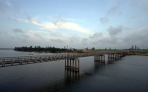
built from steel by the French in 1950. After the partition, the northern portion of the bridge was painted red and the southern portion yellow. The bridge was damaged by
American bombardment during the
292:
at Cua Tung (Tung River mouth). In the mountains, the river is named "Rao Thanh". It flows from west to east just south of the 17th parallel and close to the northern border of
299:
At the time of the partition, the principal north-south road (Highway 1) crossed the Bến Hải River over Hien Luong Bridge (also known as the "Peace Bridge"), a
363:
407:
97:
69:
76:
83:
50:
65:
308:
in 1967. U.S. jets destroyed the bridge on 5 April 1972 in order to delay invading North
Vietnamese forces during the
116:
54:
274:
17:
90:
412:
417:
402:
293:
270:
277:
separating the two parts extended about 5 kilometers (3.1 mi) from either side of the river.
43:
280:
The Bến Hải River has a total length of about 100 kilometers; its source is located in the
8:
313:
266:
246:
296:, in which it is located. At its widest point, the river is about 200 meters wide.
189:
327:
309:
289:
215:
281:
396:
378:
365:
262:
258:
257:
which became an important landmark in the partition of the country into a
305:
300:
200:
32:
331:
Looking across the Bến Hải River toward North
Vietnam, March 1968.
254:
160:
319:
141:
285:
323:
Memorial portal to Ho Chi Minh, at the Hien Luong Bridge
316:, a modern bridge was built next to the old bridge.
57:. Unsourced material may be challenged and removed.
349:"Span linking Vietnams is destroyed, U.S. says".
394:
146:Hien Luong Bridge across the Ben Hai River
117:Learn how and when to remove this message
326:
318:
14:
395:
55:adding citations to reliable sources
26:
24:
25:
429:
273:of 1954 then ended in 1976. The
140:
31:
42:needs additional citations for
342:
13:
1:
335:
167:Physical characteristics
408:Rivers of Quảng Trị province
223: • elevation
7:
353:. 8 April 1972. p. 11.
211: • location
185: • location
10:
434:
231:
221:
209:
199:
195:
183:
175:
171:
166:
156:
151:
139:
134:
275:demilitarized zone (DMZ)
253:) is a river in central
235:100 km (62 mi)
379:17.01500°N 107.11250°E
332:
324:
288:and it flows into the
284:along the border with
250:
330:
322:
227:0 m (0 ft)
51:improve this article
384:17.01500; 107.11250
375: /
314:Paris Peace Accords
413:Borders of Vietnam
351:The New York Times
333:
325:
294:Quảng Trị Province
282:Annamite Mountains
190:Annamite Mountains
418:Rivers of Vietnam
403:Vietnam War sites
239:
238:
127:
126:
119:
101:
16:(Redirected from
425:
390:
389:
387:
386:
385:
380:
376:
373:
372:
371:
368:
355:
354:
346:
310:Easter Offensive
186:
144:
132:
131:
129:River in Vietnam
122:
115:
111:
108:
102:
100:
59:
35:
27:
21:
433:
432:
428:
427:
426:
424:
423:
422:
393:
392:
383:
381:
377:
374:
369:
366:
364:
362:
361:
359:
358:
348:
347:
343:
338:
290:South China Sea
224:
216:South China Sea
212:
184:
147:
130:
123:
112:
106:
103:
66:"Bến Hải River"
60:
58:
48:
36:
23:
22:
15:
12:
11:
5:
431:
421:
420:
415:
410:
405:
357:
356:
340:
339:
337:
334:
271:Geneva Accords
237:
236:
233:
229:
228:
225:
222:
219:
218:
213:
210:
207:
206:
203:
197:
196:
193:
192:
187:
181:
180:
177:
173:
172:
169:
168:
164:
163:
158:
154:
153:
149:
148:
145:
137:
136:
128:
125:
124:
39:
37:
30:
9:
6:
4:
3:
2:
430:
419:
416:
414:
411:
409:
406:
404:
401:
400:
398:
391:
388:
352:
345:
341:
329:
321:
317:
315:
311:
307:
302:
297:
295:
291:
287:
283:
278:
276:
272:
268:
267:17th parallel
264:
263:southern zone
260:
256:
252:
248:
244:
243:Bến Hải River
234:
230:
226:
220:
217:
214:
208:
204:
202:
198:
194:
191:
188:
182:
178:
174:
170:
165:
162:
159:
155:
150:
143:
138:
135:Ben Hai River
133:
121:
118:
110:
99:
96:
92:
89:
85:
82:
78:
75:
71:
68: –
67:
63:
62:Find sources:
56:
52:
46:
45:
40:This article
38:
34:
29:
28:
19:
18:Ben Hai River
360:
350:
344:
312:. After the
298:
279:
251:Sông Bến Hải
242:
240:
113:
107:January 2022
104:
94:
87:
80:
73:
61:
49:Please help
44:verification
41:
382: /
370:107°06′45″E
306:Vietnam War
301:beam bridge
397:Categories
367:17°00′54″N
336:References
265:along the
247:Vietnamese
77:newspapers
259:northern
152:Location
269:by the
255:Vietnam
161:Vietnam
157:Country
91:scholar
261:and a
232:Length
205:
179:
176:Source
93:
86:
79:
72:
64:
201:Mouth
98:JSTOR
84:books
286:Laos
241:The
70:news
53:by
399::
249::
245:(
120:)
114:(
109:)
105:(
95:·
88:·
81:·
74:·
47:.
20:)
Text is available under the Creative Commons Attribution-ShareAlike License. Additional terms may apply.
