29:
51:
365:
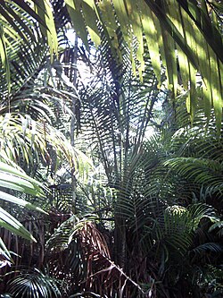
The plant communities of the ecoregion are diverse. Lowland evergreen rain forest is the most extensive, and includes alluvial forests in the plains, and hill forests in the foothills of the adjacent mountains.
565:
Eric
Dinerstein, David Olson, et al. (2017). An Ecoregion-Based Approach to Protecting Half the Terrestrial Realm, BioScience, Volume 67, Issue 6, June 2017, Pages 534–545; Supplemental material 2 table S1b.
373:
region between the Van Rees-Foja mountains and the
Central Range. The swamp forest habitats are diverse, and include grass swamps, swamp savannas, and swamp woodlands and forests dominated by
209:
116:
723:
528:
319:
288:
The
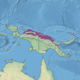
Northern New Guinea lowland rain and freshwater swamp forests extend across the northern lowlands of the island of New Guinea, lying between the
270:
83:
335:
713:
622:
413:
The ecoregion corresponds to the
Northern Papuan lowlands Endemic Bird Area. Limited-range and endemic species include the
106:
718:
101:
708:
121:
703:
698:
414:
536:
494:
246:
728:
678:
BirdLife
International (2020) "Endemic Bird Areas factsheet: Northern Papuan lowlands." Downloaded from
493:
A 2017 assessment found that 15,323 km, or 11%, of the ecoregion is in protected areas. The largest is
438:
430:
470:
454:
446:
331:
327:
289:
111:
8:
600:
478:
66:
40:
401:
71:
28:
462:
312:
297:
171:
155:
661:
515:
505:
from the foothills of the
Central Range to the sea, including the Foja Mountains.
543:
380:
342:
308:
187:
182:
35:
369:
There are extensive freshwater swamp forests in the coastal lowlands and in the
341:
The ecoregion is drained by several of New Guinea's large rivers, including the
648:
502:
323:
304:
692:
354:
293:
224:
211:
498:
395:
370:
346:
567:
422:
350:
277:
177:
645:
Terrestrial
Ecoregions of the Indo-Pacific: a Conservation Assessment.
643:
Wikramanayake, Eric; Eric
Dinerstein; Colby J. Loucks; et al. (2002).
578:
375:
301:
273:
150:
544:
Northern Papuan lowlands endemic bird area (BirdLife
International)
389:
50:
497:, which extends along the Mamberamo River and its tributaries the
193:
334:, rise from the lowlands; these ranges are home to the distinct
662:"Northern New Guinea lowland rain and freshwater swamp forests"
623:"Northern New Guinea lowland rain and freshwater swamp forests"
601:"Northern New Guinea lowland rain and freshwater swamp forests"
529:"Northern New Guinea lowland rain and freshwater swamp forests"
516:"Northern New Guinea lowland rain and freshwater swamp forests"
267:
Northern New Guinea lowland rain and freshwater swamp forests
78:
22:
Northern New Guinea lowland rain and freshwater swamp forests
679:
526:
296:to the north. It extends from the eastern shore of
318:Several east-west mountain ranges, including the
724:Tropical and subtropical moist broadleaf forests
690:
84:tropical and subtropical moist broadleaf forests
535:. National Geographic Society. Archived from
488:
603:. Digital Observatory for Protected Areas
336:Northern New Guinea montane rain forests
139:134,543 km (51,947 sq mi)
691:
561:
559:
571:
593:
556:
107:Huon Peninsula montane rain forests
13:
615:
102:Central Range montane rain forests
14:
740:
527:World Wildlife Fund, ed. (2001).
508:
122:Vogelkop-Aru lowland rain forests
415:red-breasted paradise kingfisher
49:
27:
495:Mamberamo Foja Wildlife Reserve
271:tropical moist broadleaf forest
55:Ecoregion territory (in purple)
714:Ecoregions of Papua New Guinea
672:
654:
637:
1:
549:
117:Southeast Papuan rain forests
443:Psittaculirostris salvadorii
7:
625:. The Encyclopedia of Earth
533:WildWorld Ecoregion Profile
435:Psittaculirostris edwardsii
10:
745:
283:
719:Flora of Papua New Guinea
255:
245:
240:
203:
164:
143:
135:
130:
89:
77:
65:
60:
48:
26:
21:
709:Ecoregions of New Guinea
579:"Map of Ecoregions 2017"
489:Conservation and threats
459:Pachycephala leucogastra
427:Chalcopsitta duivenbodei
408:
360:
290:New Guinea Central Range
251:Relatively stable/intact
704:Ecoregions of Indonesia
699:Australasian ecoregions
680:http://www.birdlife.org
16:Ecoregion in New Guinea
668:. World Wildlife Fund.
666:Terrestrial Ecoregions
522:. World Wildlife Fund.
520:Terrestrial Ecoregions
471:pale-billed sicklebill
455:white-bellied whistler
439:Salvadori's fig parrot
292:to the south and the
483:Gennaeodryas placens
475:Drepanornis bruijnii
467:Corvus fuscicapillus
431:Edwards's fig parrot
332:Finisterre Mountains
328:Torricelli Mountains
112:New Guinea mangroves
479:banded yellow robin
247:Conservation status
221: /
41:East Sepik Province
729:Endemic Bird Areas
419:Tanysiptera nympha
320:Van Rees Mountains
196:(Papua New Guinea)
72:Australasian realm
43:, Papua New Guinea
463:brown-headed crow
447:Brass's friarbird
263:
262:
736:
683:
676:
670:
669:
658:
652:
641:
635:
634:
632:
630:
619:
613:
612:
610:
608:
597:
591:
590:
588:
586:
575:
569:
563:
540:
523:
313:Papua New Guinea
298:Cenderawasih Bay
236:
235:
233:
232:
231:
226:
222:
219:
218:
217:
214:
156:Papua New Guinea
53:
31:
19:
18:
744:
743:
739:
738:
737:
735:
734:
733:
689:
688:
687:
686:
677:
673:
660:
659:
655:
642:
638:
628:
626:
621:
620:
616:
606:
604:
599:
598:
594:
584:
582:
577:
576:
572:
564:
557:
552:
514:
511:
491:
451:Philemon brassi
411:
385:Metroxylon sagu
363:
309:Morobe Province
286:
259:15,323 km (11%)
229:
227:
225:3.92°S 142.32°E
223:
220:
215:
212:
210:
208:
207:
199:
160:
126:
98:
97:
56:
44:
36:Metroxylon sagu
17:
12:
11:
5:
742:
732:
731:
726:
721:
716:
711:
706:
701:
685:
684:
682:on 30/05/2020.
671:
653:
649:Washington, DC
647:Island Press;
636:
614:
592:
570:
554:
553:
551:
548:
547:
546:
541:
539:on 2010-03-08.
524:
510:
509:External links
507:
490:
487:
410:
407:
362:
359:
324:Foja Mountains
305:Papua Province
285:
282:
261:
260:
257:
253:
252:
249:
243:
242:
238:
237:
205:
201:
200:
198:
197:
191:
185:
180:
175:
168:
166:
162:
161:
159:
158:
153:
147:
145:
141:
140:
137:
133:
132:
128:
127:
125:
124:
119:
114:
109:
104:
95:
94:
93:
91:
87:
86:
81:
75:
74:
69:
63:
62:
58:
57:
54:
46:
45:
32:
24:
23:
15:
9:
6:
4:
3:
2:
741:
730:
727:
725:
722:
720:
717:
715:
712:
710:
707:
705:
702:
700:
697:
696:
694:
681:
675:
667:
663:
657:
650:
646:
640:
624:
618:
602:
596:
580:
574:
568:
562:
560:
555:
545:
542:
538:
534:
530:
525:
521:
517:
513:
512:
506:
504:
500:
496:
486:
484:
480:
476:
472:
468:
464:
460:
456:
452:
448:
444:
440:
436:
432:
428:
424:
420:
416:
406:
404:
403:
398:
397:
392:
391:
386:
382:
378:
377:
372:
367:
358:
356:
352:
348:
344:
339:
337:
333:
329:
325:
321:
316:
314:
310:
306:
303:
299:
295:
294:Pacific Ocean
291:
281:
279:
275:
272:
268:
258:
254:
250:
248:
244:
239:
234:
230:-3.92; 142.32
206:
202:
195:
192:
189:
186:
184:
181:
179:
176:
173:
170:
169:
167:
163:
157:
154:
152:
149:
148:
146:
142:
138:
134:
129:
123:
120:
118:
115:
113:
110:
108:
105:
103:
100:
99:
92:
88:
85:
82:
80:
76:
73:
70:
68:
64:
59:
52:
47:
42:
38:
37:
30:
25:
20:
674:
665:
656:
644:
639:
627:. Retrieved
617:
605:. Retrieved
595:
583:. Retrieved
573:
537:the original
532:
519:
492:
482:
474:
466:
458:
450:
442:
434:
426:
418:
412:
400:
396:Campnosperma
394:
388:
384:
374:
371:Lakes Plains
368:
364:
340:
317:
287:
276:of northern
266:
264:
241:Conservation
34:
33:Sago palms (
338:ecoregion.
302:Indonesia's
228: /
204:Coordinates
174:(Indonesia)
693:Categories
629:August 20,
607:August 20,
585:August 20,
550:References
423:brown lory
402:Terminalia
278:New Guinea
178:East Sepik
581:. Resolve
399:, and/or
381:sago palm
376:Melaleuca
343:Mamberamo
274:ecoregion
256:Protected
165:Provinces
151:Indonesia
144:Countries
131:Geography
503:Taritatu
390:Pandanus
307:east to
216:142°19′E
477:), and
355:Markham
284:Setting
194:Sandaun
90:Borders
61:Ecology
499:Tariku
353:, and
349:, and
330:, and
213:3°55′S
188:Morobe
183:Madang
409:Fauna
361:Flora
347:Sepik
269:is a
172:Papua
79:Biome
67:Realm
39:) in
631:2021
609:2021
587:2021
501:and
351:Ramu
265:The
136:Area
96:List
485:).
469:),
461:),
453:),
445:),
437:),
429:),
421:),
387:),
311:of
300:in
695::
664:.
558:^
531:.
518:.
405:.
393:,
379:,
357:.
345:,
326:,
322:,
315:.
280:.
651:.
633:.
611:.
589:.
481:(
473:(
465:(
457:(
449:(
441:(
433:(
425:(
417:(
383:(
190:,
Text is available under the Creative Commons Attribution-ShareAlike License. Additional terms may apply.

