322:
excavated battle site of this age anywhere in the world. Further investigation of the site took place between 2010 and 2015. The vast scale of the battle indicates there were organized battles occurring in Bronze Age northern Europe with trained warriors and workers providing food to the warriors, which allowed the warriors to train full-time. Since writing would not reach
Northern Europe for another millennia and a half, there are no records of the battle.
413:
29:
317:) since 1997 AD and excavated since 2007. Thousands of bone fragments belonging to a very large number of persons have since been discovered along with further corroborating evidence of battle; current estimates indicate that perhaps 4,000 warriors took part in a battle on the site circa 1250 BC. These findings were possible due to the preservation of the former
321:
ground and the fact that the
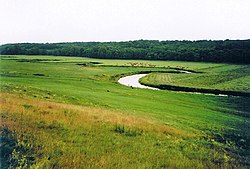
Tollense has never really changed its course. Since the population density then was about 5 people per square kilometer, this would have been the most significant battle in Bronze Age period Germany yet to be discovered. Moreover, the Tollense valley is so far the largest
284:
434:
268:
has a length of 68 km. At this junction, the discharge and basin of
Tollense is larger than the discharge and upstream basin of Peene river.
391:
125:
429:
304:
444:
202:
353:
341:
Geographische Namen. Erklärung der wichtigsten im
Schulgebrauche vorkommenden geographischen Namen
439:
392:"Brutal Bronze Age battle discovery changes understanding of history Interview with Chris Wolf"
218:
85:
56:
366:
8:
292:
51:
280:
207:
343:(in German). Leipzig: Rengersche Buchhandlung Gebhardt & Wilisch. p. 88.
272:
423:
140:
127:
249:
96:
412:
310:
241:
237:
185:
287:
from the west. The middling section of
Tollense river is joined to
222:
44:
265:
111:
28:
288:
261:
245:
226:
214:
181:
367:"Early Bronze Age battle site found on German river bank"
318:
279:. Afterwards, it is reached by two major tributaries,
260:. The section from Lake Tollense to the junction with
354:Massacre at the Tollense, Spiegel Online (German)
421:
232:The upper course begins near a small lake named
416:Tollense river and its tributaries (in blue)
364:
338:
229:. It has a total length of 95.8 km.
411:
313:have been found in the Tollense valley (
435:Rivers of Mecklenburg-Western Pomerania
298:
240:. A part of it is traditionally called
422:
271:The first kilometer of the outflow in
201:
13:
14:
456:
27:
213:"lowland, (flat) valley") is a
384:
358:
347:
332:
119: • coordinates
1:
325:
168:1,799 km (1,118 mi)
160:95.81 km (59.53 mi)
63:Physical characteristics
365:Neil Bowdler (22 May 2011).
7:
305:Tollense valley battlefield
107: • location
81: • location
10:
461:
396:Public Radio International
302:
291:river by three different
225:, right tributary of the
177:
172:
164:
156:
117:
105:
95:
91:
79:
71:
67:
62:
50:
40:
35:
26:
21:
430:Tributaries of the Peene
256:) it is nowadays called
309:Human remains from the
417:
339:Schlemmer, K. (1906).
236:, near the village of
219:Mecklenburg-Vorpommern
86:Mecklenburg-Vorpommern
57:Mecklenburg-Vorpommern
415:
199:German pronunciation:
141:53.89917°N 13.03250°E
299:Tollense battle site
248:. From this lake to
293:Pseudo-bifurcations
173:Basin features
137: /
418:
283:from the east and
244:, flowing to lake
203:[tɔˈlɛnzə]
146:53.89917; 13.03250
445:Rivers of Germany
191:
190:
452:
406:
405:
403:
402:
388:
382:
381:
379:
377:
362:
356:
351:
345:
344:
336:
221:in northeastern
205:
200:
152:
151:
149:
148:
147:
142:
138:
135:
134:
133:
130:
82:
31:
19:
18:
16:River in Germany
460:
459:
455:
454:
453:
451:
450:
449:
420:
419:
410:
409:
400:
398:
390:
389:
385:
375:
373:
363:
359:
352:
348:
337:
333:
328:
307:
301:
285:Malliner Wasser
198:
145:
143:
139:
136:
131:
128:
126:
124:
123:
120:
108:
80:
17:
12:
11:
5:
458:
448:
447:
442:
440:Tollense basin
437:
432:
408:
407:
383:
357:
346:
330:
329:
327:
324:
303:Main article:
300:
297:
273:Neubrandenburg
189:
188:
179:
175:
174:
170:
169:
166:
162:
161:
158:
154:
153:
121:
118:
115:
114:
109:
106:
103:
102:
99:
93:
92:
89:
88:
83:
77:
76:
73:
69:
68:
65:
64:
60:
59:
54:
48:
47:
42:
38:
37:
33:
32:
24:
23:
15:
9:
6:
4:
3:
2:
457:
446:
443:
441:
438:
436:
433:
431:
428:
427:
425:
414:
397:
393:
387:
372:
368:
361:
355:
350:
342:
335:
331:
323:
320:
316:
312:
306:
296:
294:
290:
286:
282:
278:
274:
269:
267:
263:
259:
255:
251:
250:Lake Tollense
247:
243:
239:
235:
230:
228:
224:
220:
216:
212:
209:
204:
196:
187:
183:
180:
176:
171:
167:
163:
159:
155:
150:
122:
116:
113:
110:
104:
100:
98:
94:
90:
87:
84:
78:
74:
70:
66:
61:
58:
55:
53:
49:
46:
43:
39:
34:
30:
25:
20:
399:. Retrieved
395:
386:
374:. Retrieved
370:
360:
349:
340:
334:
314:
308:
276:
270:
257:
253:
233:
231:
210:
194:
192:
315:Tollensetal
281:Linde river
264:river near
254:Tollensesee
178:Progression
144: /
424:Categories
401:2017-02-17
326:References
311:Bronze Age
275:is called
258:Liepskanal
242:Ziemenbach
238:Blumenholz
186:Baltic Sea
165:Basin size
129:53°53′57″N
132:13°1′57″E
371:BBC News
277:Oberbach
211:dolenica
195:Tollense
36:Location
22:Tollense
234:Mürzsee
223:Germany
206:, from
45:Germany
41:Country
376:22 May
266:Demmin
208:Slavic
157:Length
112:Demmin
101:
75:
72:Source
289:Zarow
262:Peene
246:Lieps
227:Peene
215:river
182:Peene
97:Mouth
52:State
378:2011
193:The
319:fen
217:in
426::
394:.
369:.
295:.
184:→
404:.
380:.
252:(
197:(
Text is available under the Creative Commons Attribution-ShareAlike License. Additional terms may apply.
