207:
182:
800:
400:
931:
36:
165:
214:
189:
142:
515:
the seasonally low water level, they could make no further progress and had to turn back without having achieved anything. The first
Europeans to reach the headwaters of the Meta at the foot of the Eastern Cordillera were the participants of an expedition led by the conquistador Georg Hohermuth von Speyer in 1536.
514:
In 1531, while exploring the
Orinoco river, Diego de Ordáz became the first European to discover the estuarine delta of the Meta. Following indications of a gold country at the headwaters of the river - the "Meta Province" - he and his companions navigated the Meta upstream for 50 days until, due to
466:
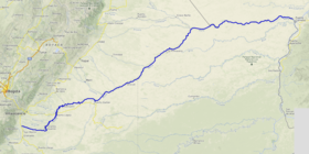
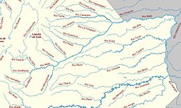
The Meta River is 1,100 km (680 mi) long and its drainage basin is 103,000 km (40,000 sq mi). The Meta divides the
Colombian Llanos in two different parts: the western portion on the left bank is more humid, receives the relatively nutrient-rich sediments from the
530:
Living along the Meta are various indigenous groups. In the upper part of the river, close to the foothills of the
Eastern Ranges and farther downstream, the
539:
324:
1058:
1014:
687:
658:
968:
747:
444:
206:
1053:
181:
100:
1007:
72:
961:
740:
119:
389:(Period of data: 1926-2011)5,694 m/s (201,100 cu ft/s) to 5,899 m/s (208,300 cu ft/s)
79:
1068:
627:
587:
424:
57:
1063:
1000:
479:, drains not to the Meta river but to the Orinoco, has a longer dry season and soils and surface waters are
86:
1038:
954:
799:
733:
1033:
53:
68:
555:
17:
631:
784:
46:
1048:
1043:
151:
8:
452:
888:
701:
559:
503:
440:
93:
706:"View of the River Meta from Orocué, near the Old Macuco Mission, Province of Casanare"
681:
652:
558:
the Meta becomes navigable, and thus is an important component of the trade across the
471:
and therefore soils and tributaries are also nutrient-rich, while the eastern portion,
448:
868:
456:
367:
103,000 km (40,000 sq mi) to 106,733 km (41,210 sq mi)
988:
942:
460:
310:
824:
766:
883:
846:
819:
518:
An 1856 watercolor by Manuel María Paz, of three indigenous people with a boat at
873:
487:
436:
432:
147:
779:
608:
984:
938:
863:
836:
789:
543:
535:
531:
491:
607:
Félix Dario, Sánchez; Martha, García; Omar, Jaramillo; Nelsy, Verdugo (2010).
1027:
910:
905:
878:
858:
841:
774:
725:
495:
412:
339:
326:
893:
499:
399:
831:
522:, near the Old Macuco Mission, is an early depiction of life on the river.
814:
291:
930:
900:
480:
420:
243:
155:
642:
519:
35:
416:
239:
705:
757:
306:
602:
600:
164:
563:
443:("Eastern Plains") of Colombia following the direction of the
597:
468:
428:
141:
606:
27:
Tributary of the
Orinoco in the Llanos of central Colombia
435:, Colombia as the confluence of the Humea, Guatiquía and
585:
581:
579:
576:
983:This article related to a river in Venezuela is a
671:
60:. Unsourced material may be challenged and removed.
586:José Rafael, Córdova; Marcelo González, Sanabria.
937:This article related to a river in Colombia is a
1025:
645:Historia General y Natural de las Indias, Vol II
439:rivers. It flows east-northeastward across the
755:
1008:
962:
741:
643:Gonzalo Fernández de Oviedo y Valdés (1959).
620:
618:
423:, South America. The Meta originates in the
1015:
1001:
969:
955:
748:
734:
686:: CS1 maint: location missing publisher (
657:: CS1 maint: location missing publisher (
615:
486:The major tributaries of the Meta are the
447:. The Meta forms the northern boundary of
146:Ferry over the Rio Meta on the road from
120:Learn how and when to remove this message
398:
14:
1026:
459:, and finally with Venezuela, down to
1059:International rivers of South America
729:
674:Elegías de varones ilustres de Indias
978:
925:
525:
58:adding citations to reliable sources
29:
24:
628:Indígenas de los Llanos Orientales
403:The Meta River and its tributaries
213:
188:
25:
1080:
463:where it flows into the Orinoco.
411:is a major left tributary of the
929:
798:
609:"Estudio Nacional del Agua 2010"
212:
205:
187:
180:
163:
140:
34:
700:
282:c. 1,300 m (4,300 ft)
45:needs additional citations for
694:
665:
636:
318: • coordinates
13:
1:
569:
250:Physical characteristics
987:. You can help Knowledge by
941:. You can help Knowledge by
672:Juan de Castellanos (1997).
278: • elevation
7:
359:1,100 km (680 mi)
302: • location
268: • location
10:
1085:
977:
924:
676:. Bogotá. pp. 410 ff.
647:. Madrid. pp. 389 ff.
549:
509:
385: • average
1054:Colombia–Venezuela border
807:
796:
764:
393:
383:
375:
371:
363:
355:
316:
300:
290:
286:
276:
266:
258:
254:
249:
235:
230:
174:
162:
139:
134:
588:"La geografía del agua"
169:Course of the Río Meta.
431:and flows through the
404:
1069:Venezuela river stubs
710:World Digital Library
632:Banco de la República
469:Andean mountain range
402:
221:Show map of Venezuela
152:San Fernando de Apure
1064:Colombia river stubs
196:Show map of Colombia
54:improve this article
1039:Rivers of Venezuela
756:Tributaries of the
453:Casanare Department
340:6.19517°N 67.4564°W
336: /
1034:Rivers of Colombia
449:Vichada Department
405:
996:
995:
950:
949:
919:
918:
702:Paz, Manuel María
564:Venezuelan Llanos
526:Indigenous groups
483:(nutrient poor).
457:Arauca Department
441:Llanos Orientales
397:
396:
345:6.19517; -67.4564
130:
129:
122:
104:
16:(Redirected from
1076:
1017:
1010:
1003:
979:
971:
964:
957:
933:
926:
802:
767:Guiana Highlands
750:
743:
736:
727:
726:
720:
719:
717:
716:
698:
692:
691:
685:
677:
669:
663:
662:
656:
648:
640:
634:
626:
622:
613:
612:
604:
595:
594:
592:
583:
386:
351:
350:
348:
347:
346:
341:
337:
334:
333:
332:
329:
279:
269:
222:
216:
215:
209:
197:
191:
190:
184:
167:
144:
132:
131:
125:
118:
114:
111:
105:
103:
62:
38:
30:
21:
1084:
1083:
1079:
1078:
1077:
1075:
1074:
1073:
1024:
1023:
1022:
1021:
976:
975:
922:
920:
915:
803:
794:
760:
754:
724:
723:
714:
712:
699:
695:
679:
678:
670:
666:
650:
649:
641:
637:
624:
623:
616:
605:
598:
590:
584:
577:
572:
552:
528:
512:
433:Meta Department
384:
344:
342:
338:
335:
330:
327:
325:
323:
322:
319:
303:
277:
267:
242:
226:
225:
224:
223:
220:
219:
218:
217:
200:
199:
198:
195:
194:
193:
192:
170:
158:
148:Puerto Ayacucho
126:
115:
109:
106:
63:
61:
51:
39:
28:
23:
22:
15:
12:
11:
5:
1082:
1072:
1071:
1066:
1061:
1056:
1051:
1046:
1041:
1036:
1020:
1019:
1012:
1005:
997:
994:
993:
974:
973:
966:
959:
951:
948:
947:
934:
917:
916:
914:
913:
908:
903:
898:
897:
896:
891:
886:
881:
876:
871:
866:
861:
851:
850:
849:
844:
834:
829:
828:
827:
822:
811:
809:
808:From elsewhere
805:
804:
797:
795:
793:
792:
787:
782:
777:
771:
769:
762:
761:
753:
752:
745:
738:
730:
722:
721:
693:
664:
635:
614:
596:
574:
573:
571:
568:
551:
548:
544:Guahibo people
527:
524:
511:
508:
461:Puerto Carreño
425:Eastern Ranges
395:
394:
391:
390:
387:
381:
380:
377:
373:
372:
369:
368:
365:
361:
360:
357:
353:
352:
320:
317:
314:
313:
311:Puerto Carreño
304:
301:
298:
297:
294:
288:
287:
284:
283:
280:
274:
273:
270:
264:
263:
260:
256:
255:
252:
251:
247:
246:
237:
233:
232:
228:
227:
211:
210:
204:
203:
202:
201:
186:
185:
179:
178:
177:
176:
175:
172:
171:
168:
160:
159:
145:
137:
136:
128:
127:
42:
40:
33:
26:
9:
6:
4:
3:
2:
1081:
1070:
1067:
1065:
1062:
1060:
1057:
1055:
1052:
1050:
1049:Border rivers
1047:
1045:
1044:Orinoco basin
1042:
1040:
1037:
1035:
1032:
1031:
1029:
1018:
1013:
1011:
1006:
1004:
999:
998:
992:
990:
986:
981:
980:
972:
967:
965:
960:
958:
953:
952:
946:
944:
940:
935:
932:
928:
927:
923:
912:
909:
907:
904:
902:
899:
895:
892:
890:
887:
885:
882:
880:
877:
875:
872:
870:
867:
865:
862:
860:
857:
856:
855:
852:
848:
845:
843:
840:
839:
838:
835:
833:
830:
826:
823:
821:
818:
817:
816:
813:
812:
810:
806:
801:
791:
788:
786:
783:
781:
778:
776:
773:
772:
770:
768:
763:
759:
751:
746:
744:
739:
737:
732:
731:
728:
711:
707:
703:
697:
689:
683:
675:
668:
660:
654:
646:
639:
633:
629:
621:
619:
610:
603:
601:
589:
582:
580:
575:
567:
565:
561:
557:
547:
545:
541:
537:
533:
523:
521:
516:
507:
505:
501:
497:
493:
489:
484:
482:
478:
474:
470:
464:
462:
458:
454:
451:, first with
450:
446:
442:
438:
434:
430:
426:
422:
419:and southern
418:
414:
413:Orinoco River
410:
401:
392:
388:
382:
378:
374:
370:
366:
362:
358:
354:
349:
321:
315:
312:
308:
305:
299:
295:
293:
289:
285:
281:
275:
271:
265:
261:
257:
253:
248:
245:
241:
238:
234:
229:
208:
183:
173:
166:
161:
157:
153:
149:
143:
138:
133:
124:
121:
113:
102:
99:
95:
92:
88:
85:
81:
78:
74:
71: –
70:
66:
65:Find sources:
59:
55:
49:
48:
43:This article
41:
37:
32:
31:
19:
989:expanding it
982:
943:expanding it
936:
921:
853:
713:. Retrieved
709:
696:
673:
667:
644:
638:
625:(in Spanish)
556:Puerto López
554:Starting at
553:
546:are living.
529:
517:
513:
485:
481:oligotrophic
476:
472:
465:
455:, then with
408:
406:
116:
107:
97:
90:
83:
76:
69:"Meta River"
64:
52:Please help
47:verification
44:
869:Cravo Norte
477:altillanura
415:in eastern
343: /
1028:Categories
889:Manacacías
825:Portuguesa
715:2014-05-21
570:References
504:Manacacías
473:high plain
445:Meta Fault
409:Meta River
364:Basin size
331:67°27′23″W
135:Meta River
80:newspapers
874:Cravo Sur
765:From the
682:cite book
653:cite book
560:Colombian
488:Cravo Sur
437:Guayuriba
421:Venezuela
376:Discharge
328:6°11′43″N
244:Venezuela
156:Venezuela
864:Casanare
837:Guaviare
790:Ventuari
506:rivers.
502:and the
492:Casanare
417:Colombia
272:Colombia
240:Colombia
231:Location
110:May 2014
18:Rio Meta
911:Vichada
906:Tuparro
884:Lengupá
879:Cusiana
859:Ariporo
847:Inírida
842:Arriari
820:Guárico
775:Atabapo
758:Orinoco
550:Economy
536:Achagua
532:Guayupe
510:History
496:Cusiana
427:of the
307:Orinoco
236:Country
94:scholar
832:Arauca
780:Caroní
540:Sáliva
520:Orocué
498:, the
494:, the
490:, the
379:
356:Length
296:
262:
259:Source
96:
89:
82:
75:
67:
815:Apure
785:Caura
591:(PDF)
429:Andes
292:Mouth
101:JSTOR
87:books
985:stub
939:stub
901:Tomo
894:Upía
854:Meta
688:link
659:link
562:and
542:and
500:Upía
407:The
73:news
475:or
309:at
154:in
150:to
56:by
1030::
708:.
704:.
684:}}
680:{{
655:}}
651:{{
630:-
617:^
599:^
578:^
566:.
538:,
534:,
1016:e
1009:t
1002:v
991:.
970:e
963:t
956:v
945:.
749:e
742:t
735:v
718:.
690:)
661:)
611:.
593:.
123:)
117:(
112:)
108:(
98:·
91:·
84:·
77:·
50:.
20:)
Text is available under the Creative Commons Attribution-ShareAlike License. Additional terms may apply.


